You are here: Home > Network List > TA - USArray Transportable Network (new EarthScope stations) Stations List
> Station M52A Chesterland, OH, USA > Earthquake Result Viewer
M52A Chesterland, OH, USA - Earthquake Result Viewer
| Earthquake location: |
South Of Panama |
| Earthquake latitude/longitude: |
7.2/-82.3 |
| Earthquake time(UTC): |
2014/05/13 (133) 06:35:24 GMT |
| Earthquake Depth: |
10 km |
| Earthquake Magnitude: |
6.8 MWP, 6.8 MI |
| Earthquake Catalog/Contributor: |
NEIC PDE/NEIC COMCAT |
|
| Network: |
TA USArray Transportable Network (new EarthScope stations) |
| Station: |
M52A Chesterland, OH, USA |
| Lat/Lon: |
41.54 N/81.36 W |
| Elevation: |
382 m |
|
| Distance: |
34.2 deg |
| Az: |
1.301 deg |
| Baz: |
181.719 deg |
| Ray Param: |
0.0778755 |
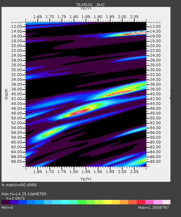
| Estimated Moho Depth: |
14.25 km |
| Estimated Crust Vp/Vs: |
2.10 |
| Assumed Crust Vp: |
6.483 km/s |
| Estimated Crust Vs: |
3.091 km/s |
| Estimated Crust Poisson's Ratio: |
0.35 |
|
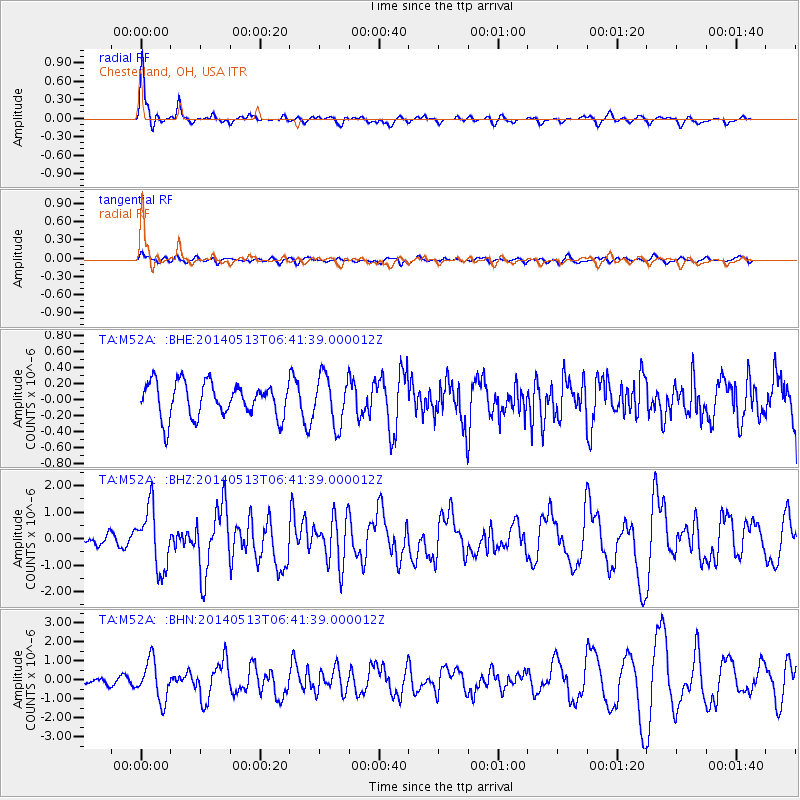
| Radial Match: |
90.4898 % |
| Radial Bump: |
308 |
| Transverse Match: |
64.1147 % |
| Transverse Bump: |
400 |
| SOD ConfigId: |
626651 |
| Insert Time: |
2014-05-27 07:32:50.898 +0000 |
| GWidth: |
2.5 |
| Max Bumps: |
400 |
| Tol: |
0.001 |
|
Signal To Noise
| Channel | StoN | STA | LTA |
| TA:M52A: :BHZ:20140513T06:41:39.000012Z | 6.8851724 | 1.1366842E-6 | 1.6509162E-7 |
| TA:M52A: :BHN:20140513T06:41:39.000012Z | 7.2574697 | 1.0239494E-6 | 1.4108903E-7 |
| TA:M52A: :BHE:20140513T06:41:39.000012Z | 1.4244704 | 3.051002E-7 | 2.1418501E-7 |
| Arrivals |
| Ps | 2.6 SECOND |
| PpPs | 6.4 SECOND |
| PsPs/PpSs | 9.0 SECOND |


