You are here: Home > Network List > TA - USArray Transportable Network (new EarthScope stations) Stations List
> Station N52A McGinn's Farm, Dalton, OH, USA > Earthquake Result Viewer
N52A McGinn's Farm, Dalton, OH, USA - Earthquake Result Viewer

| Earthquake location: |
South Of Panama |
| Earthquake latitude/longitude: |
7.2/-82.3 |
| Earthquake time(UTC): |
2014/05/13 (133) 06:35:24 GMT |
| Earthquake Depth: |
10 km |
| Earthquake Magnitude: |
6.8 MWP, 6.8 MI |
| Earthquake Catalog/Contributor: |
NEIC PDE/NEIC COMCAT |
|
| Network: |
TA USArray Transportable Network (new EarthScope stations) |
| Station: |
N52A McGinn's Farm, Dalton, OH, USA |
| Lat/Lon: |
40.81 N/81.69 W |
| Elevation: |
331 m |
|
| Distance: |
33.4 deg |
| Az: |
0.887 deg |
| Baz: |
181.16 deg |
| Ray Param: |
0.07821317 |
| Estimated Moho Depth: |
34.0 km |
| Estimated Crust Vp/Vs: |
1.95 |
| Assumed Crust Vp: |
6.483 km/s |
| Estimated Crust Vs: |
3.324 km/s |
| Estimated Crust Poisson's Ratio: |
0.32 |
|
| Radial Match: |
85.199554 % |
| Radial Bump: |
228 |
| Transverse Match: |
49.70284 % |
| Transverse Bump: |
400 |
| SOD ConfigId: |
626651 |
| Insert Time: |
2014-05-27 07:34:43.065 +0000 |
| GWidth: |
2.5 |
| Max Bumps: |
400 |
| Tol: |
0.001 |
|
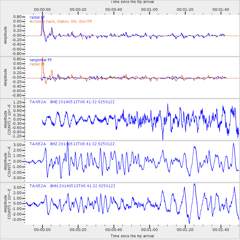
Signal To Noise
| Channel | StoN | STA | LTA |
| TA:N52A: :BHZ:20140513T06:41:32.625012Z | 5.8412666 | 1.3336855E-6 | 2.2832128E-7 |
| TA:N52A: :BHN:20140513T06:41:32.625012Z | 3.111667 | 1.054328E-6 | 3.388306E-7 |
| TA:N52A: :BHE:20140513T06:41:32.625012Z | 0.5369243 | 1.4345284E-7 | 2.6717515E-7 |
| Arrivals |
| Ps | 5.4 SECOND |
| PpPs | 14 SECOND |
| PsPs/PpSs | 20 SECOND |


