You are here: Home > Network List > TA - USArray Transportable Network (new EarthScope stations) Stations List
> Station O59A Robesonia, PA, USA > Earthquake Result Viewer
O59A Robesonia, PA, USA - Earthquake Result Viewer
| Earthquake location: |
South Of Panama |
| Earthquake latitude/longitude: |
7.2/-82.3 |
| Earthquake time(UTC): |
2014/05/13 (133) 06:35:24 GMT |
| Earthquake Depth: |
10 km |
| Earthquake Magnitude: |
6.8 MWP, 6.8 MI |
| Earthquake Catalog/Contributor: |
NEIC PDE/NEIC COMCAT |
|
| Network: |
TA USArray Transportable Network (new EarthScope stations) |
| Station: |
O59A Robesonia, PA, USA |
| Lat/Lon: |
40.31 N/76.19 W |
| Elevation: |
334 m |
|
| Distance: |
33.4 deg |
| Az: |
8.555 deg |
| Baz: |
191.128 deg |
| Ray Param: |
0.07823571 |
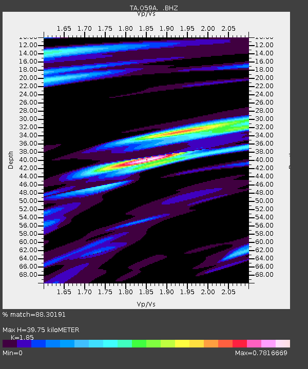
| Estimated Moho Depth: |
39.75 km |
| Estimated Crust Vp/Vs: |
1.85 |
| Assumed Crust Vp: |
6.121 km/s |
| Estimated Crust Vs: |
3.308 km/s |
| Estimated Crust Poisson's Ratio: |
0.29 |
|
| Radial Match: |
88.30191 % |
| Radial Bump: |
335 |
| Transverse Match: |
55.800476 % |
| Transverse Bump: |
400 |
| SOD ConfigId: |
626651 |
| Insert Time: |
2014-05-27 07:36:19.521 +0000 |
| GWidth: |
2.5 |
| Max Bumps: |
400 |
| Tol: |
0.001 |
|

Signal To Noise
| Channel | StoN | STA | LTA |
| TA:O59A: :BHZ:20140513T06:41:32.199994Z | 8.627456 | 1.4560067E-6 | 1.687643E-7 |
| TA:O59A: :BHN:20140513T06:41:32.199994Z | 2.161502 | 6.766985E-7 | 3.1306865E-7 |
| TA:O59A: :BHE:20140513T06:41:32.199994Z | 2.8990922 | 2.6973115E-7 | 9.303987E-8 |
| Arrivals |
| Ps | 5.9 SECOND |
| PpPs | 17 SECOND |
| PsPs/PpSs | 23 SECOND |


