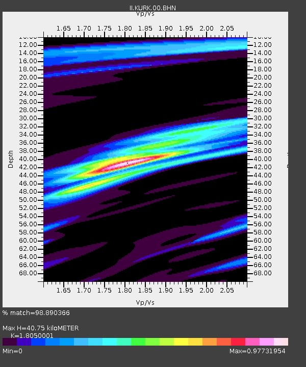
KURK Kurchatov, Kazakhstan - Earthquake Result Viewer

Earthquake location: Southern Sumatra, Indonesia
Earthquake latitude/longitude: -2.5/100.0
Earthquake time(UTC): 2008/02/25 (056) 08:36:33 GMT
Earthquake Depth: 25 km
Earthquake Magnitude: 6.4 MB, 7.3 MS, 7.0 MW, 6.9 MW
Earthquake Catalog/Contributor: WHDF/NEIC
Network: II Global Seismograph Network (GSN - IRIS/IDA)
Station: KURK Kurchatov, Kazakhstan
Lat/Lon: 50.72 N/78.62 E
Elevation: 184 m
Distance: 56.1 deg
Az: 343.8 deg
Baz: 153.996 deg
Ray Param: 0.06434872
Estimated Moho Depth: 40.75 km
Estimated Crust Vp/Vs: 1.81
Assumed Crust Vp: 6.552 km/s
Estimated Crust Vs: 3.63 km/s
Estimated Crust Poisson's Ratio: 0.28
Radial Match: 98.890366 %
Radial Bump: 321
Transverse Match: 97.181274 %
Transverse Bump: 400
SOD ConfigId: 2564
Insert Time: 2010-03-01 22:10:41.410 +0000
GWidth: 2.5
Max Bumps: 400
Tol: 0.001

Signal To Noise

ChannelStoNSTALTA
II:KURK:00:BHN:20080225T08:45:38.969026Z14.9258411.3050508E-68.743566E-8
II:KURK:00:BHE:20080225T08:45:38.970002Z6.20163156.5797775E-71.06097524E-7
II:KURK:00:BHZ:20080225T08:45:38.969026Z26.667793.236075E-61.213477E-7
Arrivals
Ps5.3 SECOND
PpPs17 SECOND
PsPs/PpSs22 SECOND