You are here: Home > Network List > TA - USArray Transportable Network (new EarthScope stations) Stations List
> Station O60A Telford, PA, USA > Earthquake Result Viewer
O60A Telford, PA, USA - Earthquake Result Viewer

| Earthquake location: |
South Of Panama |
| Earthquake latitude/longitude: |
7.2/-82.3 |
| Earthquake time(UTC): |
2014/05/13 (133) 06:35:24 GMT |
| Earthquake Depth: |
10 km |
| Earthquake Magnitude: |
6.8 MWP, 6.8 MI |
| Earthquake Catalog/Contributor: |
NEIC PDE/NEIC COMCAT |
|
| Network: |
TA USArray Transportable Network (new EarthScope stations) |
| Station: |
O60A Telford, PA, USA |
| Lat/Lon: |
40.32 N/75.40 W |
| Elevation: |
70 m |
|
| Distance: |
33.5 deg |
| Az: |
9.613 deg |
| Baz: |
192.514 deg |
| Ray Param: |
0.07817655 |
| Estimated Moho Depth: |
55.75 km |
| Estimated Crust Vp/Vs: |
1.70 |
| Assumed Crust Vp: |
6.283 km/s |
| Estimated Crust Vs: |
3.696 km/s |
| Estimated Crust Poisson's Ratio: |
0.24 |
|
| Radial Match: |
87.96701 % |
| Radial Bump: |
263 |
| Transverse Match: |
57.990906 % |
| Transverse Bump: |
400 |
| SOD ConfigId: |
626651 |
| Insert Time: |
2014-05-27 07:36:21.318 +0000 |
| GWidth: |
2.5 |
| Max Bumps: |
400 |
| Tol: |
0.001 |
|
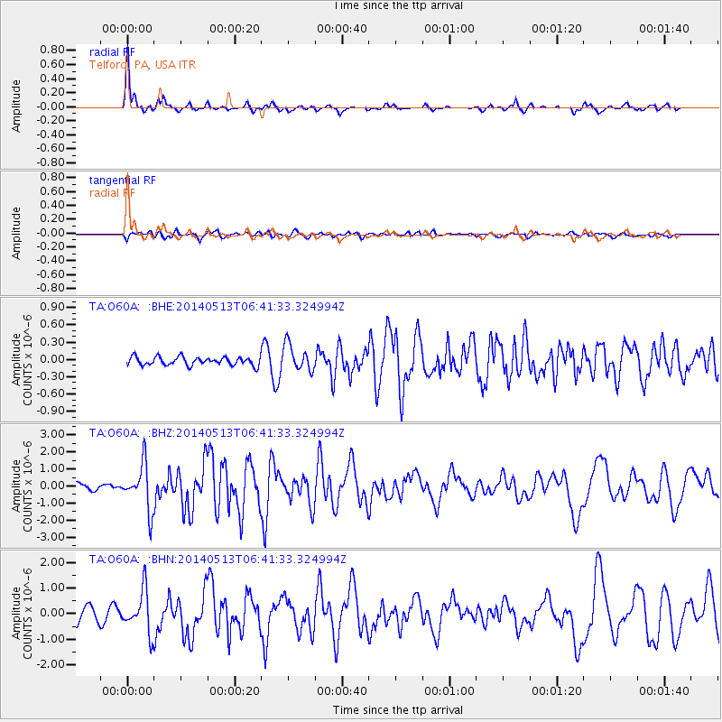
Signal To Noise
| Channel | StoN | STA | LTA |
| TA:O60A: :BHZ:20140513T06:41:33.324994Z | 4.2396407 | 1.3541355E-6 | 3.1939865E-7 |
| TA:O60A: :BHN:20140513T06:41:33.324994Z | 2.2433527 | 8.351019E-7 | 3.7225618E-7 |
| TA:O60A: :BHE:20140513T06:41:33.324994Z | 3.1701858 | 2.2797369E-7 | 7.191177E-8 |
| Arrivals |
| Ps | 6.7 SECOND |
| PpPs | 22 SECOND |
| PsPs/PpSs | 29 SECOND |


