You are here: Home > Network List > TA - USArray Transportable Network (new EarthScope stations) Stations List
> Station P54A Burton, WV, USA > Earthquake Result Viewer
P54A Burton, WV, USA - Earthquake Result Viewer
| Earthquake location: |
South Of Panama |
| Earthquake latitude/longitude: |
7.2/-82.3 |
| Earthquake time(UTC): |
2014/05/13 (133) 06:35:24 GMT |
| Earthquake Depth: |
10 km |
| Earthquake Magnitude: |
6.8 MWP, 6.8 MI |
| Earthquake Catalog/Contributor: |
NEIC PDE/NEIC COMCAT |
|
| Network: |
TA USArray Transportable Network (new EarthScope stations) |
| Station: |
P54A Burton, WV, USA |
| Lat/Lon: |
39.61 N/80.48 W |
| Elevation: |
473 m |
|
| Distance: |
32.3 deg |
| Az: |
2.678 deg |
| Baz: |
183.44 deg |
| Ray Param: |
0.07872666 |
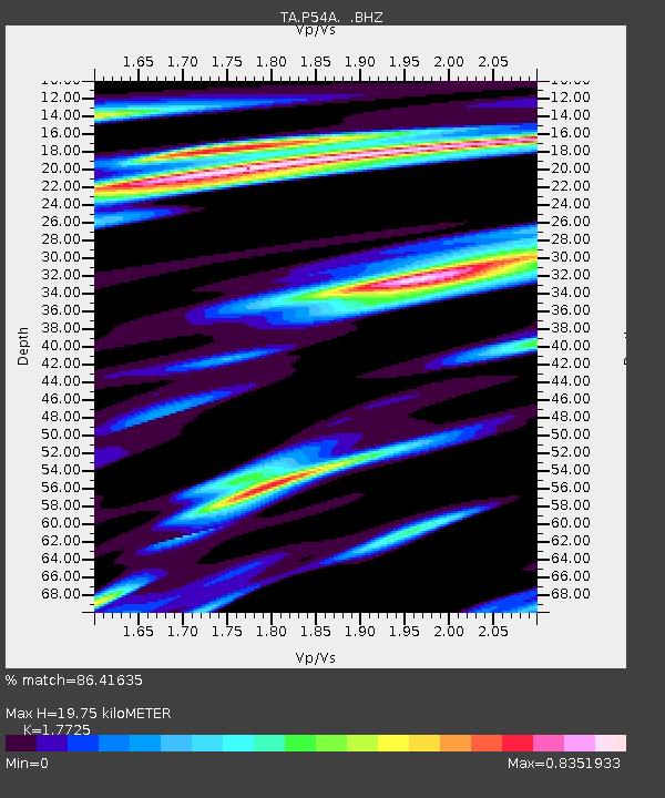
| Estimated Moho Depth: |
19.75 km |
| Estimated Crust Vp/Vs: |
1.77 |
| Assumed Crust Vp: |
6.207 km/s |
| Estimated Crust Vs: |
3.502 km/s |
| Estimated Crust Poisson's Ratio: |
0.27 |
|
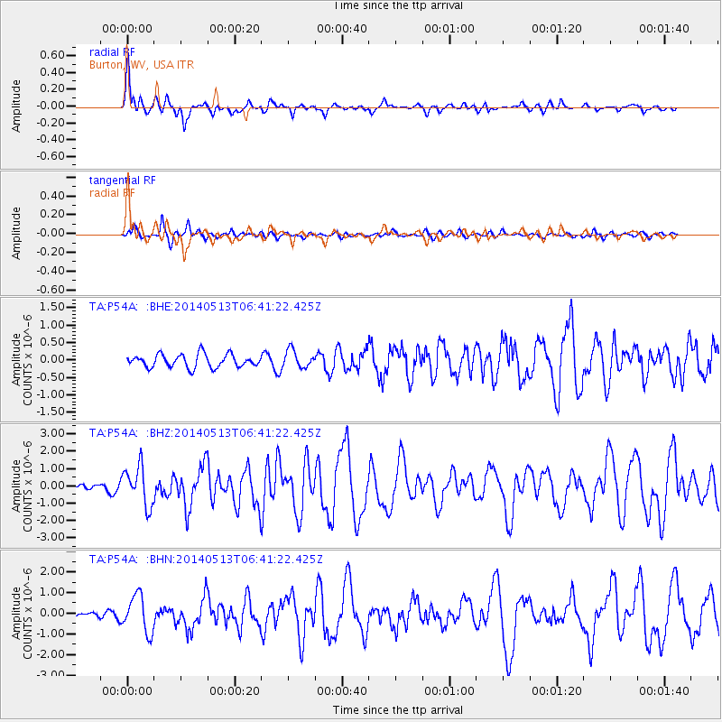
| Radial Match: |
86.41635 % |
| Radial Bump: |
385 |
| Transverse Match: |
78.11171 % |
| Transverse Bump: |
400 |
| SOD ConfigId: |
626651 |
| Insert Time: |
2014-05-27 07:36:51.690 +0000 |
| GWidth: |
2.5 |
| Max Bumps: |
400 |
| Tol: |
0.001 |
|
Signal To Noise
| Channel | StoN | STA | LTA |
| TA:P54A: :BHZ:20140513T06:41:22.425Z | 3.120422 | 1.1407241E-6 | 3.6556727E-7 |
| TA:P54A: :BHN:20140513T06:41:22.425Z | 2.5534995 | 9.036429E-7 | 3.5388413E-7 |
| TA:P54A: :BHE:20140513T06:41:22.425Z | 1.3606458 | 2.535153E-7 | 1.8631984E-7 |
| Arrivals |
| Ps | 2.6 SECOND |
| PpPs | 8.2 SECOND |
| PsPs/PpSs | 11 SECOND |


