You are here: Home > Network List > TA - USArray Transportable Network (new EarthScope stations) Stations List
> Station P59A Jarrettsville, MD, USA > Earthquake Result Viewer
P59A Jarrettsville, MD, USA - Earthquake Result Viewer
| Earthquake location: |
South Of Panama |
| Earthquake latitude/longitude: |
7.2/-82.3 |
| Earthquake time(UTC): |
2014/05/13 (133) 06:35:24 GMT |
| Earthquake Depth: |
10 km |
| Earthquake Magnitude: |
6.8 MWP, 6.8 MI |
| Earthquake Catalog/Contributor: |
NEIC PDE/NEIC COMCAT |
|
| Network: |
TA USArray Transportable Network (new EarthScope stations) |
| Station: |
P59A Jarrettsville, MD, USA |
| Lat/Lon: |
39.61 N/76.43 W |
| Elevation: |
157 m |
|
| Distance: |
32.7 deg |
| Az: |
8.459 deg |
| Baz: |
190.89 deg |
| Ray Param: |
0.078560285 |
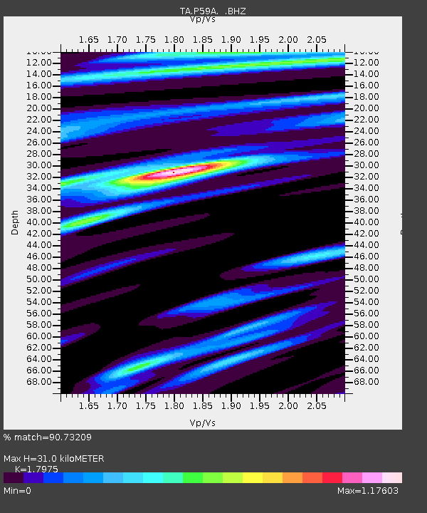
| Estimated Moho Depth: |
31.0 km |
| Estimated Crust Vp/Vs: |
1.80 |
| Assumed Crust Vp: |
6.419 km/s |
| Estimated Crust Vs: |
3.571 km/s |
| Estimated Crust Poisson's Ratio: |
0.28 |
|
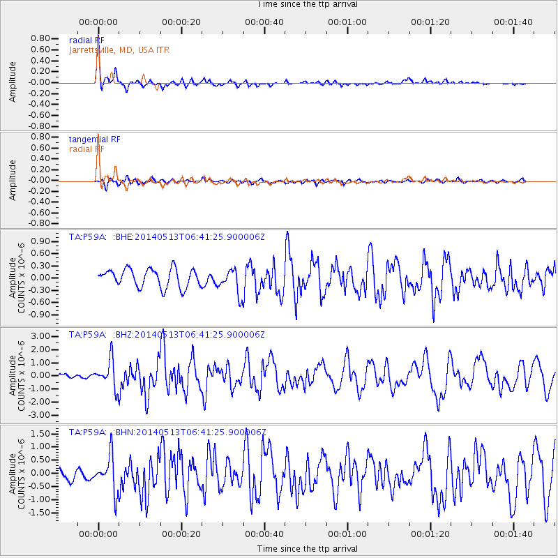
| Radial Match: |
90.73209 % |
| Radial Bump: |
313 |
| Transverse Match: |
60.991943 % |
| Transverse Bump: |
400 |
| SOD ConfigId: |
626651 |
| Insert Time: |
2014-05-27 07:37:08.633 +0000 |
| GWidth: |
2.5 |
| Max Bumps: |
400 |
| Tol: |
0.001 |
|
Signal To Noise
| Channel | StoN | STA | LTA |
| TA:P59A: :BHZ:20140513T06:41:25.900006Z | 5.9096193 | 1.0943012E-6 | 1.8517288E-7 |
| TA:P59A: :BHN:20140513T06:41:25.900006Z | 4.179878 | 7.101795E-7 | 1.6990435E-7 |
| TA:P59A: :BHE:20140513T06:41:25.900006Z | 1.476884 | 3.2789723E-7 | 2.2201961E-7 |
| Arrivals |
| Ps | 4.2 SECOND |
| PpPs | 13 SECOND |
| PsPs/PpSs | 17 SECOND |


