You are here: Home > Network List > TA - USArray Transportable Network (new EarthScope stations) Stations List
> Station P61A Hammonton, NJ, USA > Earthquake Result Viewer
P61A Hammonton, NJ, USA - Earthquake Result Viewer

| Earthquake location: |
South Of Panama |
| Earthquake latitude/longitude: |
7.2/-82.3 |
| Earthquake time(UTC): |
2014/05/13 (133) 06:35:24 GMT |
| Earthquake Depth: |
10 km |
| Earthquake Magnitude: |
6.8 MWP, 6.8 MI |
| Earthquake Catalog/Contributor: |
NEIC PDE/NEIC COMCAT |
|
| Network: |
TA USArray Transportable Network (new EarthScope stations) |
| Station: |
P61A Hammonton, NJ, USA |
| Lat/Lon: |
39.67 N/74.79 W |
| Elevation: |
22 m |
|
| Distance: |
33.0 deg |
| Az: |
10.717 deg |
| Baz: |
193.83 deg |
| Ray Param: |
0.078416266 |
| Estimated Moho Depth: |
23.75 km |
| Estimated Crust Vp/Vs: |
2.10 |
| Assumed Crust Vp: |
6.287 km/s |
| Estimated Crust Vs: |
2.998 km/s |
| Estimated Crust Poisson's Ratio: |
0.35 |
|
| Radial Match: |
89.928314 % |
| Radial Bump: |
353 |
| Transverse Match: |
72.22996 % |
| Transverse Bump: |
400 |
| SOD ConfigId: |
626651 |
| Insert Time: |
2014-05-27 07:37:16.695 +0000 |
| GWidth: |
2.5 |
| Max Bumps: |
400 |
| Tol: |
0.001 |
|
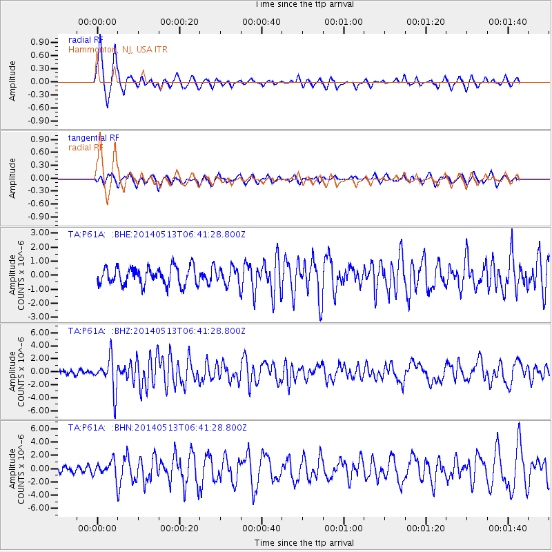
Signal To Noise
| Channel | StoN | STA | LTA |
| TA:P61A: :BHZ:20140513T06:41:28.800Z | 9.506791 | 2.609975E-6 | 2.7453797E-7 |
| TA:P61A: :BHN:20140513T06:41:28.800Z | 3.002378 | 1.1912102E-6 | 3.967556E-7 |
| TA:P61A: :BHE:20140513T06:41:28.800Z | 0.9317161 | 5.8871535E-7 | 6.318613E-7 |
| Arrivals |
| Ps | 4.4 SECOND |
| PpPs | 11 SECOND |
| PsPs/PpSs | 15 SECOND |


