You are here: Home > Network List > TA - USArray Transportable Network (new EarthScope stations) Stations List
> Station R53A Hurricane, WV, USA > Earthquake Result Viewer
R53A Hurricane, WV, USA - Earthquake Result Viewer
| Earthquake location: |
South Of Panama |
| Earthquake latitude/longitude: |
7.2/-82.3 |
| Earthquake time(UTC): |
2014/05/13 (133) 06:35:24 GMT |
| Earthquake Depth: |
10 km |
| Earthquake Magnitude: |
6.8 MWP, 6.8 MI |
| Earthquake Catalog/Contributor: |
NEIC PDE/NEIC COMCAT |
|
| Network: |
TA USArray Transportable Network (new EarthScope stations) |
| Station: |
R53A Hurricane, WV, USA |
| Lat/Lon: |
38.33 N/81.95 W |
| Elevation: |
294 m |
|
| Distance: |
30.9 deg |
| Az: |
0.579 deg |
| Baz: |
180.73 deg |
| Ray Param: |
0.0791991 |
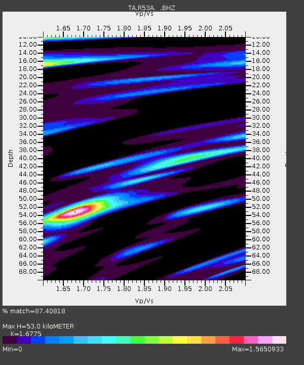
| Estimated Moho Depth: |
53.0 km |
| Estimated Crust Vp/Vs: |
1.68 |
| Assumed Crust Vp: |
6.207 km/s |
| Estimated Crust Vs: |
3.7 km/s |
| Estimated Crust Poisson's Ratio: |
0.22 |
|
| Radial Match: |
87.40818 % |
| Radial Bump: |
360 |
| Transverse Match: |
65.46178 % |
| Transverse Bump: |
360 |
| SOD ConfigId: |
626651 |
| Insert Time: |
2014-05-27 07:38:18.061 +0000 |
| GWidth: |
2.5 |
| Max Bumps: |
400 |
| Tol: |
0.001 |
|

Signal To Noise
| Channel | StoN | STA | LTA |
| TA:R53A: :BHZ:20140513T06:41:10.925Z | 5.998193 | 1.5934843E-6 | 2.656607E-7 |
| TA:R53A: :BHN:20140513T06:41:10.925Z | 3.160225 | 6.9066516E-7 | 2.1854936E-7 |
| TA:R53A: :BHE:20140513T06:41:10.925Z | 1.1825242 | 3.4202208E-7 | 2.8923048E-7 |
| Arrivals |
| Ps | 6.3 SECOND |
| PpPs | 21 SECOND |
| PsPs/PpSs | 27 SECOND |


