You are here: Home > Network List > US - United States National Seismic Network Stations List
> Station WMOK Wichita Mountains, Oklahoma, USA > Earthquake Result Viewer
WMOK Wichita Mountains, Oklahoma, USA - Earthquake Result Viewer
| Earthquake location: |
South Of Panama |
| Earthquake latitude/longitude: |
7.2/-82.3 |
| Earthquake time(UTC): |
2014/05/13 (133) 06:35:24 GMT |
| Earthquake Depth: |
10 km |
| Earthquake Magnitude: |
6.8 MWP, 6.8 MI |
| Earthquake Catalog/Contributor: |
NEIC PDE/NEIC COMCAT |
|
| Network: |
US United States National Seismic Network |
| Station: |
WMOK Wichita Mountains, Oklahoma, USA |
| Lat/Lon: |
34.74 N/98.78 W |
| Elevation: |
486 m |
|
| Distance: |
31.3 deg |
| Az: |
333.301 deg |
| Baz: |
147.231 deg |
| Ray Param: |
0.07911303 |
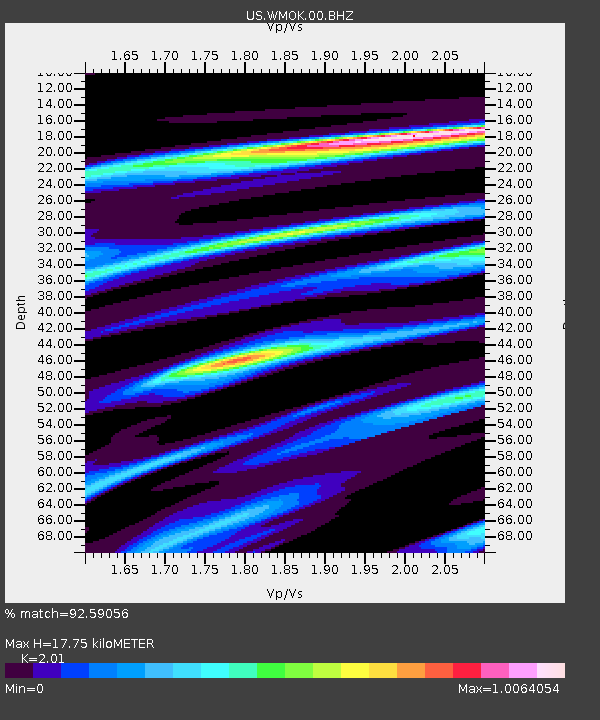
| Estimated Moho Depth: |
17.75 km |
| Estimated Crust Vp/Vs: |
2.01 |
| Assumed Crust Vp: |
6.315 km/s |
| Estimated Crust Vs: |
3.142 km/s |
| Estimated Crust Poisson's Ratio: |
0.34 |
|
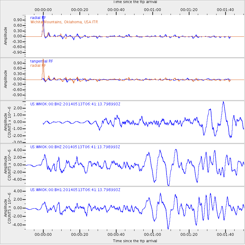
| Radial Match: |
92.59056 % |
| Radial Bump: |
242 |
| Transverse Match: |
66.975655 % |
| Transverse Bump: |
400 |
| SOD ConfigId: |
626651 |
| Insert Time: |
2014-05-27 07:43:29.838 +0000 |
| GWidth: |
2.5 |
| Max Bumps: |
400 |
| Tol: |
0.001 |
|
Signal To Noise
| Channel | StoN | STA | LTA |
| US:WMOK:00:BHZ:20140513T06:41:13.798993Z | 9.961558 | 1.4686048E-6 | 1.4742722E-7 |
| US:WMOK:00:BH1:20140513T06:41:13.798993Z | 5.6177344 | 7.760691E-7 | 1.3814626E-7 |
| US:WMOK:00:BH2:20140513T06:41:13.798993Z | 4.84172 | 5.479785E-7 | 1.1317848E-7 |
| Arrivals |
| Ps | 3.0 SECOND |
| PpPs | 7.9 SECOND |
| PsPs/PpSs | 11 SECOND |


