You are here: Home > Network List > UW - Pacific Northwest Regional Seismic Network Stations List
> Station LEBA Lebam, WA, USA > Earthquake Result Viewer
LEBA Lebam, WA, USA - Earthquake Result Viewer
| Earthquake location: |
South Of Panama |
| Earthquake latitude/longitude: |
7.2/-82.3 |
| Earthquake time(UTC): |
2014/05/13 (133) 06:35:24 GMT |
| Earthquake Depth: |
10 km |
| Earthquake Magnitude: |
6.8 MWP, 6.8 MI |
| Earthquake Catalog/Contributor: |
NEIC PDE/NEIC COMCAT |
|
| Network: |
UW Pacific Northwest Regional Seismic Network |
| Station: |
LEBA Lebam, WA, USA |
| Lat/Lon: |
46.55 N/123.56 W |
| Elevation: |
73 m |
|
| Distance: |
52.7 deg |
| Az: |
325.129 deg |
| Baz: |
124.733 deg |
| Ray Param: |
0.066577174 |
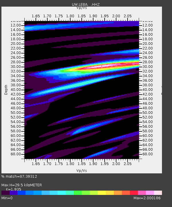
| Estimated Moho Depth: |
29.5 km |
| Estimated Crust Vp/Vs: |
1.93 |
| Assumed Crust Vp: |
6.566 km/s |
| Estimated Crust Vs: |
3.393 km/s |
| Estimated Crust Poisson's Ratio: |
0.32 |
|
| Radial Match: |
87.39312 % |
| Radial Bump: |
400 |
| Transverse Match: |
79.79517 % |
| Transverse Bump: |
400 |
| SOD ConfigId: |
626651 |
| Insert Time: |
2014-05-27 07:46:33.160 +0000 |
| GWidth: |
2.5 |
| Max Bumps: |
400 |
| Tol: |
0.001 |
|
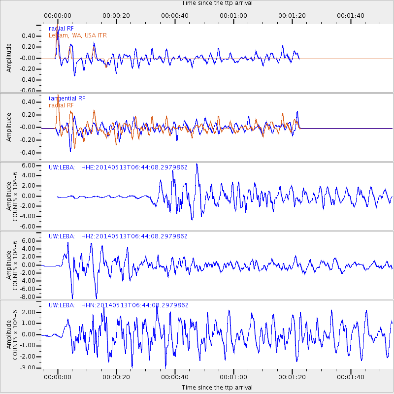
Signal To Noise
| Channel | StoN | STA | LTA |
| UW:LEBA: :HHZ:20140513T06:44:08.297986Z | 23.322868 | 2.2387942E-6 | 9.5991375E-8 |
| UW:LEBA: :HHN:20140513T06:44:08.297986Z | 6.102641 | 6.008221E-7 | 9.8452794E-8 |
| UW:LEBA: :HHE:20140513T06:44:08.297986Z | 6.9771094 | 8.680082E-7 | 1.24408E-7 |
| Arrivals |
| Ps | 4.4 SECOND |
| PpPs | 13 SECOND |
| PsPs/PpSs | 17 SECOND |


