You are here: Home > Network List > UW - Pacific Northwest Regional Seismic Network Stations List
> Station MRBL Marblemount, WA, USA > Earthquake Result Viewer
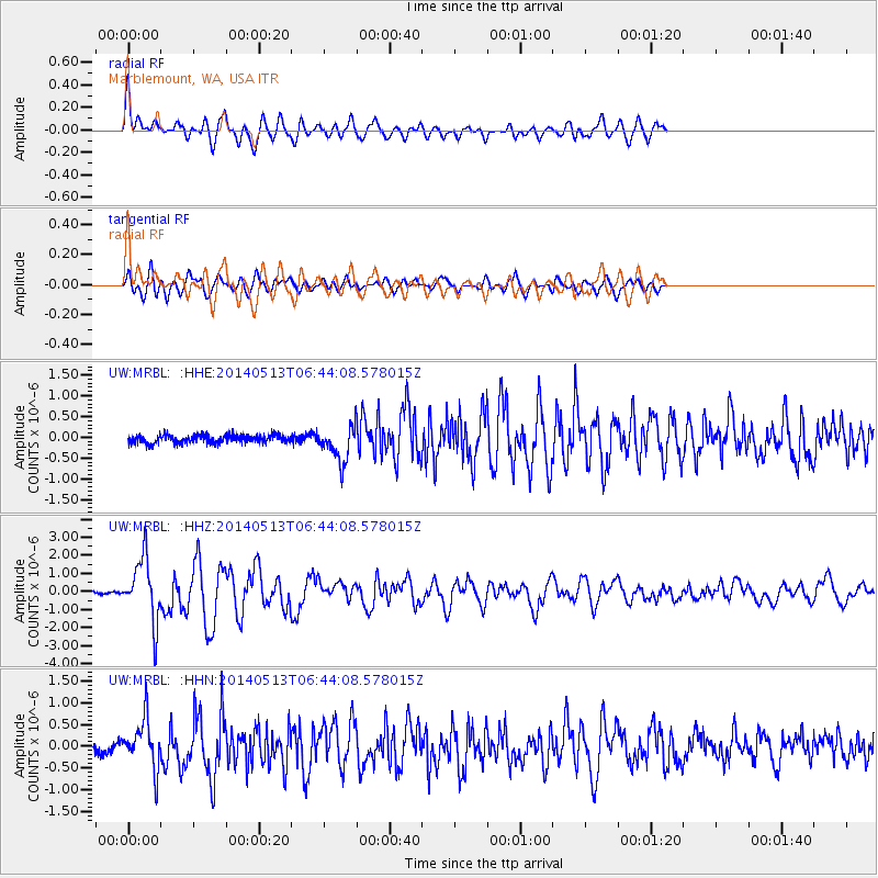
MRBL Marblemount, WA, USA - Earthquake Result Viewer
*The percent match for this event was below the threshold and hence no stack was calculated.
| Earthquake location: |
South Of Panama |
| Earthquake latitude/longitude: |
7.2/-82.3 |
| Earthquake time(UTC): |
2014/05/13 (133) 06:35:24 GMT |
| Earthquake Depth: |
10 km |
| Earthquake Magnitude: |
6.8 MWP, 6.8 MI |
| Earthquake Catalog/Contributor: |
NEIC PDE/NEIC COMCAT |
|
| Network: |
UW Pacific Northwest Regional Seismic Network |
| Station: |
MRBL Marblemount, WA, USA |
| Lat/Lon: |
48.52 N/121.48 W |
| Elevation: |
75 m |
|
| Distance: |
52.8 deg |
| Az: |
328.175 deg |
| Baz: |
128.107 deg |
| Ray Param: |
$rayparam |
*The percent match for this event was below the threshold and hence was not used in the summary stack. |
|
| Radial Match: |
67.54713 % |
| Radial Bump: |
400 |
| Transverse Match: |
52.541977 % |
| Transverse Bump: |
400 |
| SOD ConfigId: |
626651 |
| Insert Time: |
2014-05-27 07:46:50.560 +0000 |
| GWidth: |
2.5 |
| Max Bumps: |
400 |
| Tol: |
0.001 |
|
Signal To Noise
| Channel | StoN | STA | LTA |
| UW:MRBL: :HHZ:20140513T06:44:08.578015Z | 17.089136 | 1.7339445E-6 | 1.0146472E-7 |
| UW:MRBL: :HHN:20140513T06:44:08.578015Z | 3.3593457 | 5.582097E-7 | 1.661662E-7 |
| UW:MRBL: :HHE:20140513T06:44:08.578015Z | 4.215031 | 4.2085205E-7 | 9.984554E-8 |
| Arrivals |
| Ps | |
| PpPs | |
| PsPs/PpSs | |


