You are here: Home > Network List > UW - Pacific Northwest Regional Seismic Network Stations List
> Station UMAT Pilot Rock, OR, USA > Earthquake Result Viewer
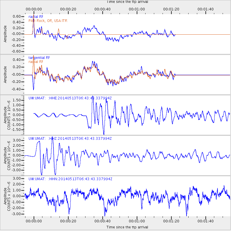
UMAT Pilot Rock, OR, USA - Earthquake Result Viewer
*The percent match for this event was below the threshold and hence no stack was calculated.
| Earthquake location: |
South Of Panama |
| Earthquake latitude/longitude: |
7.2/-82.3 |
| Earthquake time(UTC): |
2014/05/13 (133) 06:35:24 GMT |
| Earthquake Depth: |
10 km |
| Earthquake Magnitude: |
6.8 MWP, 6.8 MI |
| Earthquake Catalog/Contributor: |
NEIC PDE/NEIC COMCAT |
|
| Network: |
UW Pacific Northwest Regional Seismic Network |
| Station: |
UMAT Pilot Rock, OR, USA |
| Lat/Lon: |
45.29 N/118.96 W |
| Elevation: |
1318 m |
|
| Distance: |
49.4 deg |
| Az: |
326.308 deg |
| Baz: |
128.772 deg |
| Ray Param: |
$rayparam |
*The percent match for this event was below the threshold and hence was not used in the summary stack. |
|
| Radial Match: |
69.44106 % |
| Radial Bump: |
400 |
| Transverse Match: |
63.42766 % |
| Transverse Bump: |
400 |
| SOD ConfigId: |
626651 |
| Insert Time: |
2014-05-27 07:47:35.547 +0000 |
| GWidth: |
2.5 |
| Max Bumps: |
400 |
| Tol: |
0.001 |
|
Signal To Noise
| Channel | StoN | STA | LTA |
| UW:UMAT: :HHZ:20140513T06:43:43.337994Z | 25.173656 | 2.1235896E-6 | 8.4357616E-8 |
| UW:UMAT: :HHN:20140513T06:43:43.337994Z | 1.132328 | 5.7073555E-7 | 5.0403725E-7 |
| UW:UMAT: :HHE:20140513T06:43:43.337994Z | 9.339799 | 9.99531E-7 | 1.0701847E-7 |
| Arrivals |
| Ps | |
| PpPs | |
| PsPs/PpSs | |


