You are here: Home > Network List > CI - Caltech Regional Seismic Network Stations List
> Station MPM Manuel Prospect Mine, California, USA > Earthquake Result Viewer
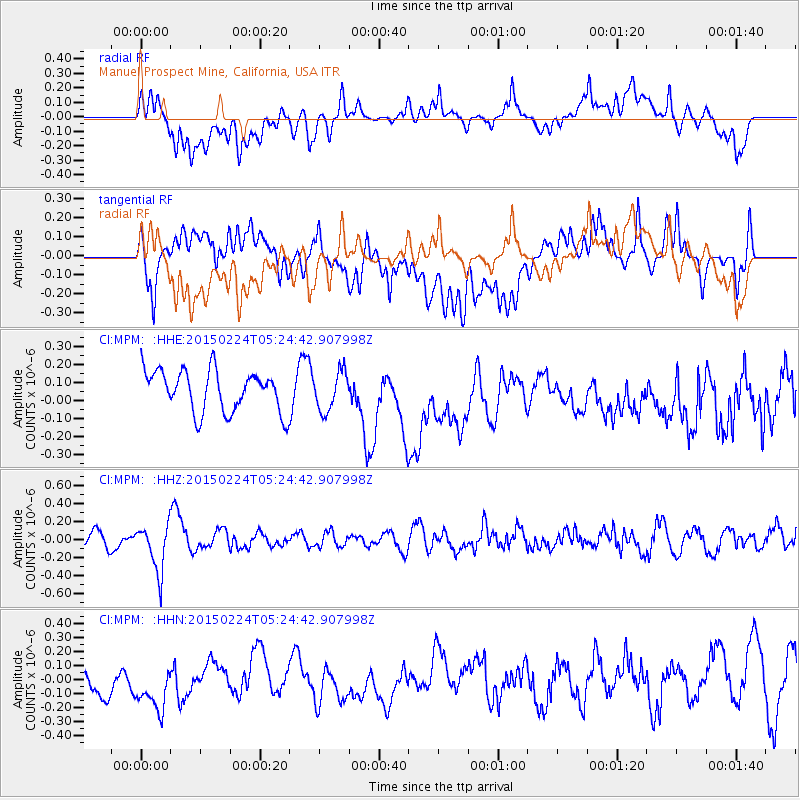
MPM Manuel Prospect Mine, California, USA - Earthquake Result Viewer
*The percent match for this event was below the threshold and hence no stack was calculated.
| Earthquake location: |
Jujuy Province, Argentina |
| Earthquake latitude/longitude: |
-22.7/-66.8 |
| Earthquake time(UTC): |
2015/02/24 (055) 05:13:51 GMT |
| Earthquake Depth: |
204 km |
| Earthquake Magnitude: |
5.3 MW |
| Earthquake Catalog/Contributor: |
ISC/ISC |
|
| Network: |
CI Caltech Regional Seismic Network |
| Station: |
MPM Manuel Prospect Mine, California, USA |
| Lat/Lon: |
36.06 N/117.49 W |
| Elevation: |
185 m |
|
| Distance: |
75.6 deg |
| Az: |
319.63 deg |
| Baz: |
132.417 deg |
| Ray Param: |
$rayparam |
*The percent match for this event was below the threshold and hence was not used in the summary stack. |
|
| Radial Match: |
43.517624 % |
| Radial Bump: |
400 |
| Transverse Match: |
53.71596 % |
| Transverse Bump: |
400 |
| SOD ConfigId: |
7019011 |
| Insert Time: |
2019-04-17 01:30:14.593 +0000 |
| GWidth: |
2.5 |
| Max Bumps: |
400 |
| Tol: |
0.001 |
|
Signal To Noise
| Channel | StoN | STA | LTA |
| CI:MPM: :HHZ:20150224T05:24:42.907998Z | 2.240427 | 2.6842685E-7 | 1.1981057E-7 |
| CI:MPM: :HHN:20150224T05:24:42.907998Z | 1.714066 | 2.0782166E-7 | 1.2124484E-7 |
| CI:MPM: :HHE:20150224T05:24:42.907998Z | 0.95074254 | 1.0777715E-7 | 1.1336102E-7 |
| Arrivals |
| Ps | |
| PpPs | |
| PsPs/PpSs | |


