You are here: Home > Network List > TA - USArray Transportable Network (new EarthScope stations) Stations List
> Station G59A Clarenceville, QC, USA > Earthquake Result Viewer
G59A Clarenceville, QC, USA - Earthquake Result Viewer
| Earthquake location: |
Jujuy Province, Argentina |
| Earthquake latitude/longitude: |
-22.7/-66.8 |
| Earthquake time(UTC): |
2015/02/24 (055) 05:13:51 GMT |
| Earthquake Depth: |
204 km |
| Earthquake Magnitude: |
5.3 MW |
| Earthquake Catalog/Contributor: |
ISC/ISC |
|
| Network: |
TA USArray Transportable Network (new EarthScope stations) |
| Station: |
G59A Clarenceville, QC, USA |
| Lat/Lon: |
45.08 N/73.18 W |
| Elevation: |
36 m |
|
| Distance: |
67.7 deg |
| Az: |
355.085 deg |
| Baz: |
173.588 deg |
| Ray Param: |
0.056207534 |
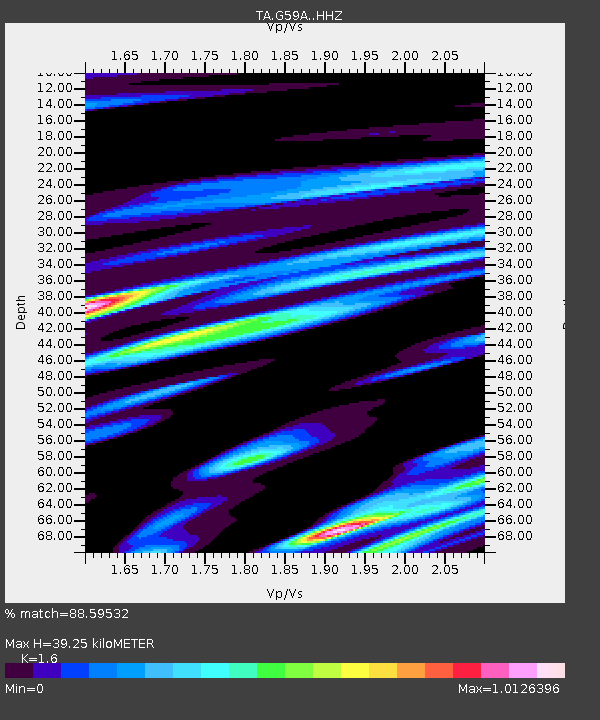
| Estimated Moho Depth: |
39.25 km |
| Estimated Crust Vp/Vs: |
1.60 |
| Assumed Crust Vp: |
6.419 km/s |
| Estimated Crust Vs: |
4.012 km/s |
| Estimated Crust Poisson's Ratio: |
0.18 |
|
| Radial Match: |
88.59532 % |
| Radial Bump: |
257 |
| Transverse Match: |
45.505814 % |
| Transverse Bump: |
285 |
| SOD ConfigId: |
7019011 |
| Insert Time: |
2019-04-17 01:34:47.046 +0000 |
| GWidth: |
2.5 |
| Max Bumps: |
400 |
| Tol: |
0.001 |
|
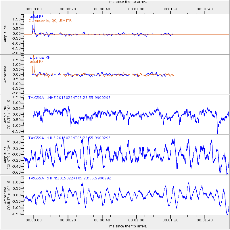
Signal To Noise
| Channel | StoN | STA | LTA |
| TA:G59A: :HHZ:20150224T05:23:55.990029Z | 0.6856333 | 2.2986328E-7 | 3.3525689E-7 |
| TA:G59A: :HHN:20150224T05:23:55.990029Z | 0.6691953 | 4.1027457E-7 | 6.1308646E-7 |
| TA:G59A: :HHE:20150224T05:23:55.990029Z | 0.9778854 | 3.5700617E-7 | 3.6507973E-7 |
| Arrivals |
| Ps | 3.8 SECOND |
| PpPs | 15 SECOND |
| PsPs/PpSs | 19 SECOND |


