You are here: Home > Network List > TA - USArray Transportable Network (new EarthScope stations) Stations List
> Station C36M Paulatuk, NT, CAN > Earthquake Result Viewer
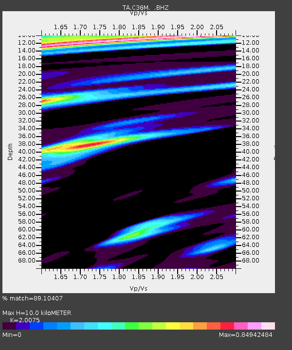
C36M Paulatuk, NT, CAN - Earthquake Result Viewer
| Earthquake location: |
E. Caroline Islands, Micronesia |
| Earthquake latitude/longitude: |
6.5/144.9 |
| Earthquake time(UTC): |
2014/05/14 (134) 20:56:13 GMT |
| Earthquake Depth: |
10 km |
| Earthquake Magnitude: |
6.1 MI |
| Earthquake Catalog/Contributor: |
NEIC PDE/NEIC ALERT |
|
| Network: |
TA USArray Transportable Network (new EarthScope stations) |
| Station: |
C36M Paulatuk, NT, CAN |
| Lat/Lon: |
69.35 N/124.07 W |
| Elevation: |
10 m |
|
| Distance: |
84.4 deg |
| Az: |
20.881 deg |
| Baz: |
273.267 deg |
| Ray Param: |
0.04552666 |
| Estimated Moho Depth: |
10.0 km |
| Estimated Crust Vp/Vs: |
2.01 |
| Assumed Crust Vp: |
6.459 km/s |
| Estimated Crust Vs: |
3.218 km/s |
| Estimated Crust Poisson's Ratio: |
0.33 |
|
| Radial Match: |
89.10407 % |
| Radial Bump: |
391 |
| Transverse Match: |
78.610405 % |
| Transverse Bump: |
400 |
| SOD ConfigId: |
626651 |
| Insert Time: |
2014-05-28 21:23:54.767 +0000 |
| GWidth: |
2.5 |
| Max Bumps: |
400 |
| Tol: |
0.001 |
|

Signal To Noise
| Channel | StoN | STA | LTA |
| TA:C36M: :BHZ:20140514T21:08:14.075024Z | 2.3802354 | 2.0151445E-7 | 8.466156E-8 |
| TA:C36M: :BHN:20140514T21:08:14.075024Z | 0.75037205 | 5.624906E-8 | 7.496156E-8 |
| TA:C36M: :BHE:20140514T21:08:14.075024Z | 1.0959293 | 8.092221E-8 | 7.38389E-8 |
| Arrivals |
| Ps | 1.6 SECOND |
| PpPs | 4.6 SECOND |
| PsPs/PpSs | 6.1 SECOND |


