You are here: Home > Network List > TA - USArray Transportable Network (new EarthScope stations) Stations List
> Station H17A Grant Village (NPS), Yellowstone Nt. Park, WY, USA > Earthquake Result Viewer
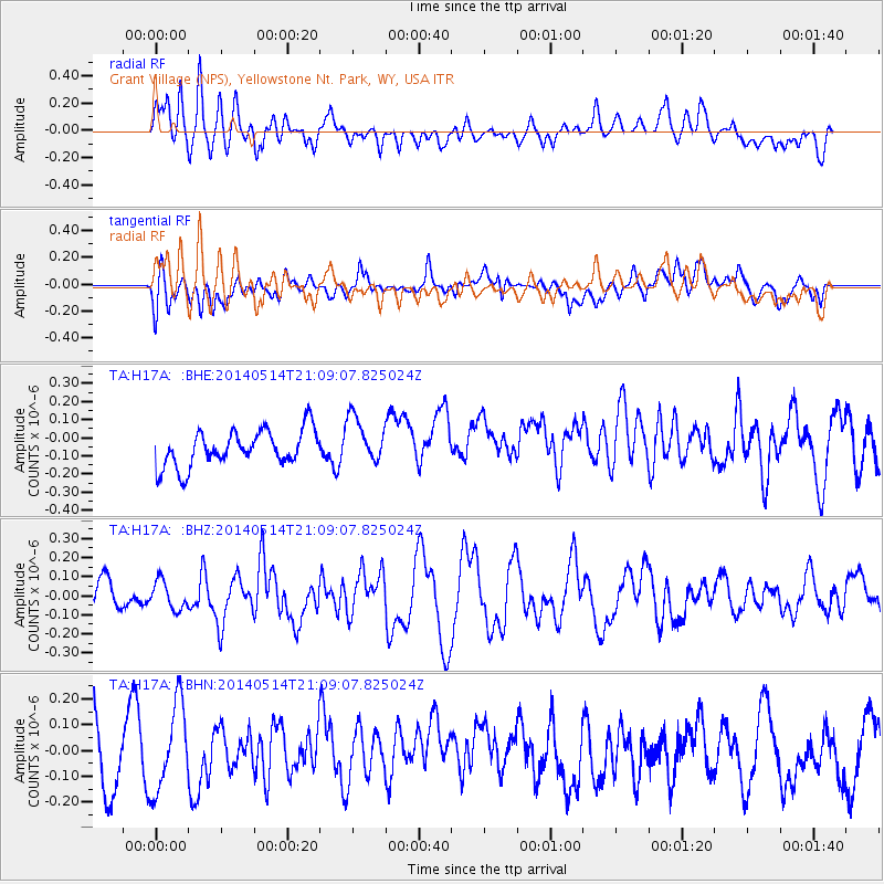
H17A Grant Village (NPS), Yellowstone Nt. Park, WY, USA - Earthquake Result Viewer
*The percent match for this event was below the threshold and hence no stack was calculated.
| Earthquake location: |
E. Caroline Islands, Micronesia |
| Earthquake latitude/longitude: |
6.5/144.9 |
| Earthquake time(UTC): |
2014/05/14 (134) 20:56:13 GMT |
| Earthquake Depth: |
10 km |
| Earthquake Magnitude: |
6.1 MI |
| Earthquake Catalog/Contributor: |
NEIC PDE/NEIC ALERT |
|
| Network: |
TA USArray Transportable Network (new EarthScope stations) |
| Station: |
H17A Grant Village (NPS), Yellowstone Nt. Park, WY, USA |
| Lat/Lon: |
44.40 N/110.58 W |
| Elevation: |
2400 m |
|
| Distance: |
95.8 deg |
| Az: |
44.224 deg |
| Baz: |
284.799 deg |
| Ray Param: |
$rayparam |
*The percent match for this event was below the threshold and hence was not used in the summary stack. |
|
| Radial Match: |
55.05011 % |
| Radial Bump: |
400 |
| Transverse Match: |
49.509056 % |
| Transverse Bump: |
400 |
| SOD ConfigId: |
626651 |
| Insert Time: |
2014-05-28 21:24:14.967 +0000 |
| GWidth: |
2.5 |
| Max Bumps: |
400 |
| Tol: |
0.001 |
|
Signal To Noise
| Channel | StoN | STA | LTA |
| TA:H17A: :BHZ:20140514T21:09:07.825024Z | 0.67487776 | 7.287064E-8 | 1.0797606E-7 |
| TA:H17A: :BHN:20140514T21:09:07.825024Z | 1.357227 | 1.7107351E-7 | 1.2604636E-7 |
| TA:H17A: :BHE:20140514T21:09:07.825024Z | 1.3081622 | 1.3091253E-7 | 1.0007362E-7 |
| Arrivals |
| Ps | |
| PpPs | |
| PsPs/PpSs | |


