You are here: Home > Network List > AK - Alaska Regional Network Stations List
> Station YAH Yahtse, AK, USA > Earthquake Result Viewer
YAH Yahtse, AK, USA - Earthquake Result Viewer
| Earthquake location: |
E. Caroline Islands, Micronesia |
| Earthquake latitude/longitude: |
6.5/144.9 |
| Earthquake time(UTC): |
2014/05/15 (135) 08:16:34 GMT |
| Earthquake Depth: |
10 km |
| Earthquake Magnitude: |
6.6 MWP, 6.6 MI |
| Earthquake Catalog/Contributor: |
NEIC PDE/NEIC COMCAT |
|
| Network: |
AK Alaska Regional Network |
| Station: |
YAH Yahtse, AK, USA |
| Lat/Lon: |
60.36 N/141.75 W |
| Elevation: |
2125 m |
|
| Distance: |
76.2 deg |
| Az: |
29.373 deg |
| Baz: |
258.651 deg |
| Ray Param: |
0.05118226 |
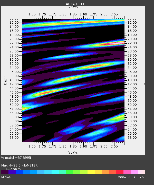
| Estimated Moho Depth: |
21.5 km |
| Estimated Crust Vp/Vs: |
2.10 |
| Assumed Crust Vp: |
6.566 km/s |
| Estimated Crust Vs: |
3.13 km/s |
| Estimated Crust Poisson's Ratio: |
0.35 |
|
| Radial Match: |
87.5995 % |
| Radial Bump: |
386 |
| Transverse Match: |
89.8259 % |
| Transverse Bump: |
400 |
| SOD ConfigId: |
626651 |
| Insert Time: |
2014-05-29 08:30:43.136 +0000 |
| GWidth: |
2.5 |
| Max Bumps: |
400 |
| Tol: |
0.001 |
|

Signal To Noise
| Channel | StoN | STA | LTA |
| AK:YAH: :BHZ:20140515T08:27:51.728015Z | 3.8468368 | 2.8895494E-7 | 7.511494E-8 |
| AK:YAH: :BHN:20140515T08:27:51.728015Z | 1.2837799 | 1.6358948E-7 | 1.2742798E-7 |
| AK:YAH: :BHE:20140515T08:27:51.728015Z | 1.6348529 | 1.9247155E-7 | 1.1773019E-7 |
| Arrivals |
| Ps | 3.7 SECOND |
| PpPs | 9.9 SECOND |
| PsPs/PpSs | 14 SECOND |


