You are here: Home > Network List > AU - Australian Seismological Centre Stations List
> Station PSAC2 Pilbara Seismic Array Element C2 > Earthquake Result Viewer
PSAC2 Pilbara Seismic Array Element C2 - Earthquake Result Viewer
| Earthquake location: |
E. Caroline Islands, Micronesia |
| Earthquake latitude/longitude: |
6.5/144.9 |
| Earthquake time(UTC): |
2014/05/15 (135) 08:16:34 GMT |
| Earthquake Depth: |
10 km |
| Earthquake Magnitude: |
6.6 MWP, 6.6 MI |
| Earthquake Catalog/Contributor: |
NEIC PDE/NEIC COMCAT |
|
| Network: |
AU Australian Seismological Centre |
| Station: |
PSAC2 Pilbara Seismic Array Element C2 |
| Lat/Lon: |
21.56 S/119.90 E |
| Elevation: |
330 m |
|
| Distance: |
37.1 deg |
| Az: |
220.656 deg |
| Baz: |
44.063 deg |
| Ray Param: |
0.07629682 |
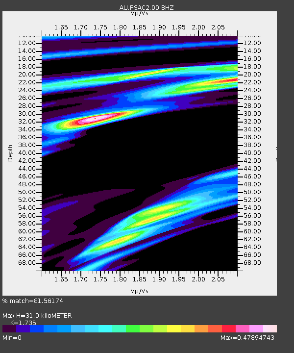
| Estimated Moho Depth: |
31.0 km |
| Estimated Crust Vp/Vs: |
1.74 |
| Assumed Crust Vp: |
6.464 km/s |
| Estimated Crust Vs: |
3.725 km/s |
| Estimated Crust Poisson's Ratio: |
0.25 |
|
| Radial Match: |
81.56174 % |
| Radial Bump: |
400 |
| Transverse Match: |
72.67022 % |
| Transverse Bump: |
400 |
| SOD ConfigId: |
626651 |
| Insert Time: |
2014-05-29 08:33:01.265 +0000 |
| GWidth: |
2.5 |
| Max Bumps: |
400 |
| Tol: |
0.001 |
|

Signal To Noise
| Channel | StoN | STA | LTA |
| AU:PSAC2:00:BHZ:20140515T08:23:14.943988Z | 3.1332996 | 2.177055E-6 | 6.948123E-7 |
| AU:PSAC2:00:BH1:20140515T08:23:14.943988Z | 0.9873612 | 4.549962E-7 | 4.6082044E-7 |
| AU:PSAC2:00:BH2:20140515T08:23:14.943988Z | 0.9034938 | 4.6135386E-7 | 5.1063313E-7 |
| Arrivals |
| Ps | 3.8 SECOND |
| PpPs | 12 SECOND |
| PsPs/PpSs | 16 SECOND |


