You are here: Home > Network List > AU - Australian Seismological Centre Stations List
> Station PSAD3 Pilbara Seismic Array Element D3 > Earthquake Result Viewer
PSAD3 Pilbara Seismic Array Element D3 - Earthquake Result Viewer
| Earthquake location: |
E. Caroline Islands, Micronesia |
| Earthquake latitude/longitude: |
6.5/144.9 |
| Earthquake time(UTC): |
2014/05/15 (135) 08:16:34 GMT |
| Earthquake Depth: |
10 km |
| Earthquake Magnitude: |
6.6 MWP, 6.6 MI |
| Earthquake Catalog/Contributor: |
NEIC PDE/NEIC COMCAT |
|
| Network: |
AU Australian Seismological Centre |
| Station: |
PSAD3 Pilbara Seismic Array Element D3 |
| Lat/Lon: |
21.64 S/119.78 E |
| Elevation: |
327 m |
|
| Distance: |
37.3 deg |
| Az: |
220.697 deg |
| Baz: |
44.14 deg |
| Ray Param: |
0.076222956 |
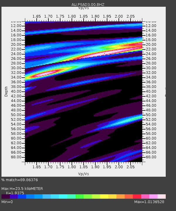
| Estimated Moho Depth: |
23.5 km |
| Estimated Crust Vp/Vs: |
1.94 |
| Assumed Crust Vp: |
6.464 km/s |
| Estimated Crust Vs: |
3.336 km/s |
| Estimated Crust Poisson's Ratio: |
0.32 |
|
| Radial Match: |
89.86376 % |
| Radial Bump: |
217 |
| Transverse Match: |
54.559414 % |
| Transverse Bump: |
400 |
| SOD ConfigId: |
626651 |
| Insert Time: |
2014-05-29 08:33:10.320 +0000 |
| GWidth: |
2.5 |
| Max Bumps: |
400 |
| Tol: |
0.001 |
|

Signal To Noise
| Channel | StoN | STA | LTA |
| AU:PSAD3:00:BHZ:20140515T08:23:16.094012Z | 3.90414 | 1.949104E-6 | 4.992403E-7 |
| AU:PSAD3:00:BH1:20140515T08:23:16.094012Z | 1.6562184 | 4.5150995E-7 | 2.7261498E-7 |
| AU:PSAD3:00:BH2:20140515T08:23:16.094012Z | 3.736931 | 1.4071102E-6 | 3.7654164E-7 |
| Arrivals |
| Ps | 3.6 SECOND |
| PpPs | 10.0 SECOND |
| PsPs/PpSs | 14 SECOND |


