You are here: Home > Network List > S - Seismographs in Schools Projects Stations List
> Station AUPHS Peel High School, NSW, Australia > Earthquake Result Viewer
AUPHS Peel High School, NSW, Australia - Earthquake Result Viewer
| Earthquake location: |
E. Caroline Islands, Micronesia |
| Earthquake latitude/longitude: |
6.5/144.9 |
| Earthquake time(UTC): |
2014/05/15 (135) 08:16:34 GMT |
| Earthquake Depth: |
10 km |
| Earthquake Magnitude: |
6.6 MWP, 6.6 MI |
| Earthquake Catalog/Contributor: |
NEIC PDE/NEIC COMCAT |
|
| Network: |
S Seismographs in Schools Projects |
| Station: |
AUPHS Peel High School, NSW, Australia |
| Lat/Lon: |
31.10 S/150.89 E |
| Elevation: |
404 m |
|
| Distance: |
37.8 deg |
| Az: |
171.601 deg |
| Baz: |
350.259 deg |
| Ray Param: |
0.07591234 |
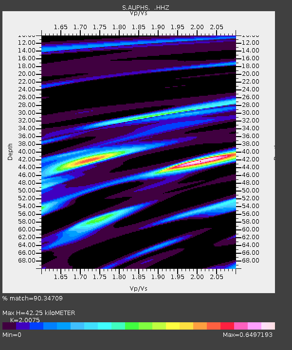
| Estimated Moho Depth: |
42.25 km |
| Estimated Crust Vp/Vs: |
2.01 |
| Assumed Crust Vp: |
6.577 km/s |
| Estimated Crust Vs: |
3.276 km/s |
| Estimated Crust Poisson's Ratio: |
0.33 |
|
| Radial Match: |
90.34709 % |
| Radial Bump: |
260 |
| Transverse Match: |
70.355576 % |
| Transverse Bump: |
400 |
| SOD ConfigId: |
626651 |
| Insert Time: |
2014-05-29 08:48:21.206 +0000 |
| GWidth: |
2.5 |
| Max Bumps: |
400 |
| Tol: |
0.001 |
|

Signal To Noise
| Channel | StoN | STA | LTA |
| S:AUPHS: :HHZ:20140515T08:23:20.770007Z | 13.106675 | 1.2435E-5 | 9.487532E-7 |
| S:AUPHS: :HHN:20140515T08:23:20.770007Z | 4.9137745 | 6.60468E-6 | 1.3441155E-6 |
| S:AUPHS: :HHE:20140515T08:23:20.770007Z | 7.566388 | 4.236538E-6 | 5.599155E-7 |
| Arrivals |
| Ps | 6.9 SECOND |
| PpPs | 18 SECOND |
| PsPs/PpSs | 25 SECOND |


