You are here: Home > Network List > II - Global Seismograph Network (GSN - IRIS/IDA) Stations List
> Station KURK Kurchatov, Kazakhstan > Earthquake Result Viewer
KURK Kurchatov, Kazakhstan - Earthquake Result Viewer
| Earthquake location: |
Kuril Islands |
| Earthquake latitude/longitude: |
45.3/149.9 |
| Earthquake time(UTC): |
1996/02/07 (038) 21:36:45 GMT |
| Earthquake Depth: |
33 km |
| Earthquake Magnitude: |
6.3 MB, 7.0 MS, 7.2 UNKNOWN, 7.1 MW |
| Earthquake Catalog/Contributor: |
WHDF/NEIC |
|
| Network: |
II Global Seismograph Network (GSN - IRIS/IDA) |
| Station: |
KURK Kurchatov, Kazakhstan |
| Lat/Lon: |
50.72 N/78.62 E |
| Elevation: |
184 m |
|
| Distance: |
46.3 deg |
| Az: |
303.602 deg |
| Baz: |
67.571 deg |
| Ray Param: |
0.07066935 |
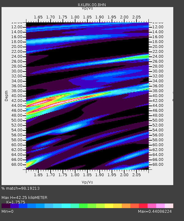
| Estimated Moho Depth: |
42.25 km |
| Estimated Crust Vp/Vs: |
1.76 |
| Assumed Crust Vp: |
6.552 km/s |
| Estimated Crust Vs: |
3.728 km/s |
| Estimated Crust Poisson's Ratio: |
0.26 |
|
| Radial Match: |
98.19213 % |
| Radial Bump: |
303 |
| Transverse Match: |
80.8354 % |
| Transverse Bump: |
400 |
| SOD ConfigId: |
6273 |
| Insert Time: |
2010-03-01 22:14:35.540 +0000 |
| GWidth: |
2.5 |
| Max Bumps: |
400 |
| Tol: |
0.001 |
|

Signal To Noise
| Channel | StoN | STA | LTA |
| II:KURK:00:BHN:19960207T21:44:37.058008Z | 4.356296 | 6.0412447E-7 | 1.3867847E-7 |
| II:KURK:00:BHE:19960207T21:44:37.058008Z | 12.187716 | 2.0753714E-6 | 1.7028387E-7 |
| II:KURK:00:BHZ:19960207T21:44:37.058008Z | 18.128586 | 3.993771E-6 | 2.203024E-7 |
| Arrivals |
| Ps | 5.2 SECOND |
| PpPs | 17 SECOND |
| PsPs/PpSs | 22 SECOND |


