You are here: Home > Network List > CI - Caltech Regional Seismic Network Stations List
> Station VCS Vincent Substation, Palmdale, CA, USA > Earthquake Result Viewer
VCS Vincent Substation, Palmdale, CA, USA - Earthquake Result Viewer
| Earthquake location: |
Central Alaska |
| Earthquake latitude/longitude: |
63.5/-147.9 |
| Earthquake time(UTC): |
2002/10/23 (296) 11:27:19 GMT |
| Earthquake Depth: |
4.2 km |
| Earthquake Magnitude: |
6.0 MB, 6.7 MS, 6.7 MW, 6.7 MW |
| Earthquake Catalog/Contributor: |
WHDF/NEIC |
|
| Network: |
CI Caltech Regional Seismic Network |
| Station: |
VCS Vincent Substation, Palmdale, CA, USA |
| Lat/Lon: |
34.48 N/118.12 W |
| Elevation: |
991 m |
|
| Distance: |
34.4 deg |
| Az: |
133.394 deg |
| Baz: |
336.77 deg |
| Ray Param: |
0.077778876 |
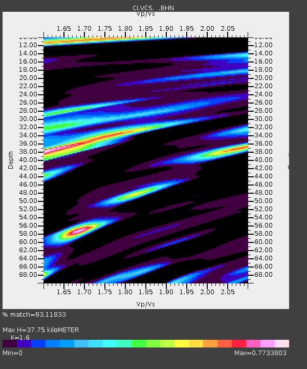
| Estimated Moho Depth: |
37.75 km |
| Estimated Crust Vp/Vs: |
1.60 |
| Assumed Crust Vp: |
6.1 km/s |
| Estimated Crust Vs: |
3.812 km/s |
| Estimated Crust Poisson's Ratio: |
0.18 |
|
| Radial Match: |
93.11833 % |
| Radial Bump: |
289 |
| Transverse Match: |
77.75934 % |
| Transverse Bump: |
400 |
| SOD ConfigId: |
3787 |
| Insert Time: |
2010-02-25 21:04:58.735 +0000 |
| GWidth: |
2.5 |
| Max Bumps: |
400 |
| Tol: |
0.001 |
|
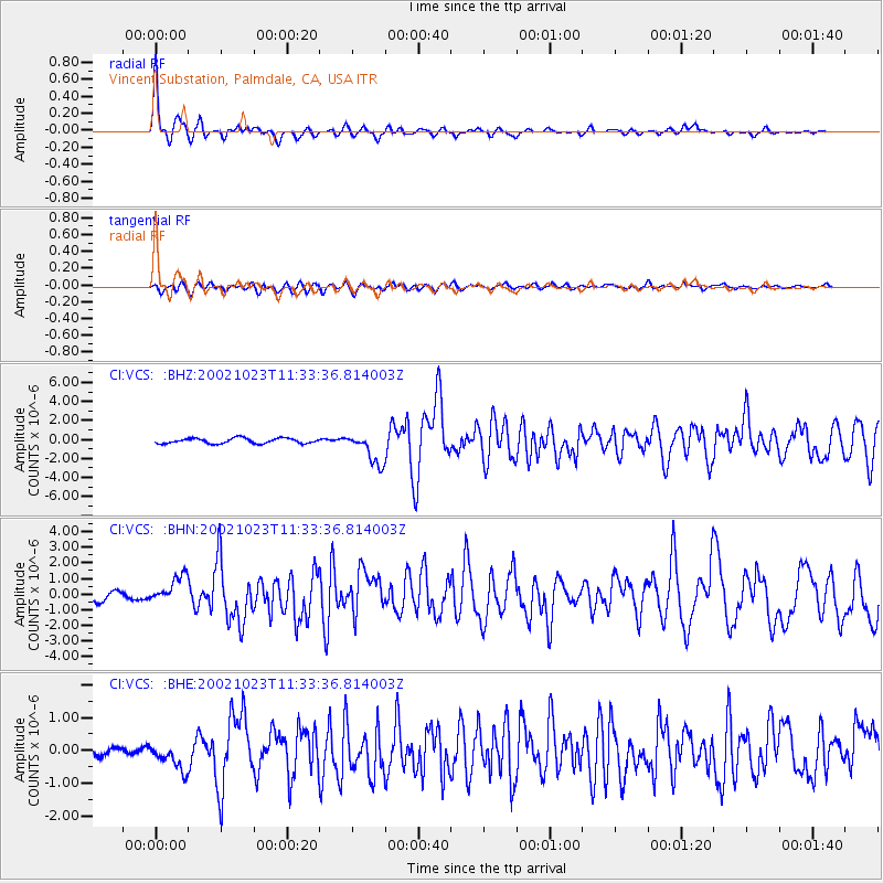
Signal To Noise
| Channel | StoN | STA | LTA |
| CI:VCS: :BHN:20021023T11:33:36.814003Z | 3.243446 | 8.8424554E-7 | 2.7262533E-7 |
| CI:VCS: :BHE:20021023T11:33:36.814003Z | 1.7169654 | 4.112915E-7 | 2.3954559E-7 |
| CI:VCS: :BHZ:20021023T11:33:36.814003Z | 6.0232954 | 1.677402E-6 | 2.7848577E-7 |
| Arrivals |
| Ps | 4.0 SECOND |
| PpPs | 15 SECOND |
| PsPs/PpSs | 19 SECOND |


