You are here: Home > Network List > TA - USArray Transportable Network (new EarthScope stations) Stations List
> Station O03E Paynes Creek, CA, USA > Earthquake Result Viewer
O03E Paynes Creek, CA, USA - Earthquake Result Viewer
| Earthquake location: |
E. Caroline Islands, Micronesia |
| Earthquake latitude/longitude: |
6.5/144.9 |
| Earthquake time(UTC): |
2014/05/15 (135) 08:16:34 GMT |
| Earthquake Depth: |
10 km |
| Earthquake Magnitude: |
6.6 MWP, 6.6 MI |
| Earthquake Catalog/Contributor: |
NEIC PDE/NEIC COMCAT |
|
| Network: |
TA USArray Transportable Network (new EarthScope stations) |
| Station: |
O03E Paynes Creek, CA, USA |
| Lat/Lon: |
40.29 N/121.80 W |
| Elevation: |
967 m |
|
| Distance: |
88.3 deg |
| Az: |
49.811 deg |
| Baz: |
277.066 deg |
| Ray Param: |
0.04265294 |
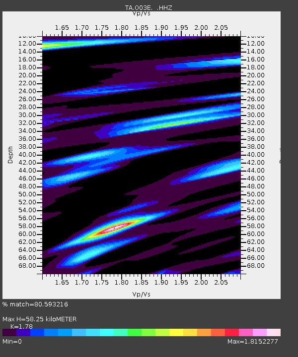
| Estimated Moho Depth: |
58.25 km |
| Estimated Crust Vp/Vs: |
1.78 |
| Assumed Crust Vp: |
6.566 km/s |
| Estimated Crust Vs: |
3.689 km/s |
| Estimated Crust Poisson's Ratio: |
0.27 |
|
| Radial Match: |
80.593216 % |
| Radial Bump: |
400 |
| Transverse Match: |
88.4295 % |
| Transverse Bump: |
383 |
| SOD ConfigId: |
626651 |
| Insert Time: |
2014-05-29 08:50:45.057 +0000 |
| GWidth: |
2.5 |
| Max Bumps: |
400 |
| Tol: |
0.001 |
|
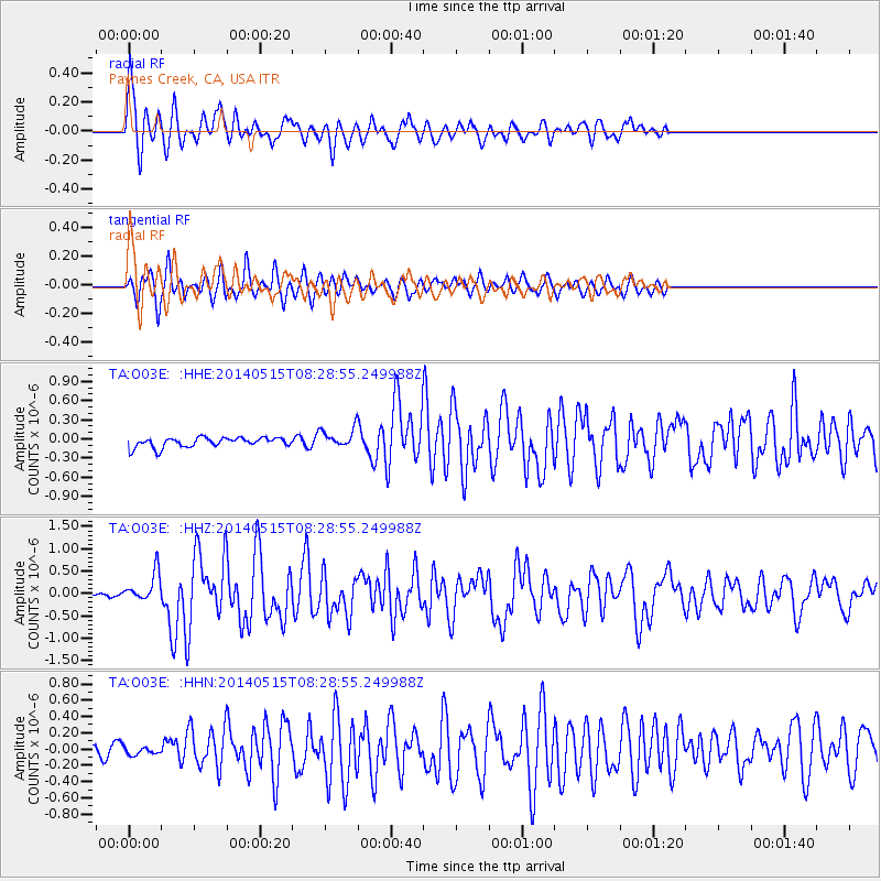
Signal To Noise
| Channel | StoN | STA | LTA |
| TA:O03E: :HHZ:20140515T08:28:55.249988Z | 5.5202255 | 3.2269327E-7 | 5.845654E-8 |
| TA:O03E: :HHN:20140515T08:28:55.249988Z | 0.88881344 | 4.669959E-8 | 5.2541502E-8 |
| TA:O03E: :HHE:20140515T08:28:55.249988Z | 1.9562495 | 1.507952E-7 | 7.7083826E-8 |
| Arrivals |
| Ps | 7.1 SECOND |
| PpPs | 24 SECOND |
| PsPs/PpSs | 31 SECOND |


