You are here: Home > Network List > AK - Alaska Regional Network Stations List
> Station MDM Murphy Dome > Earthquake Result Viewer
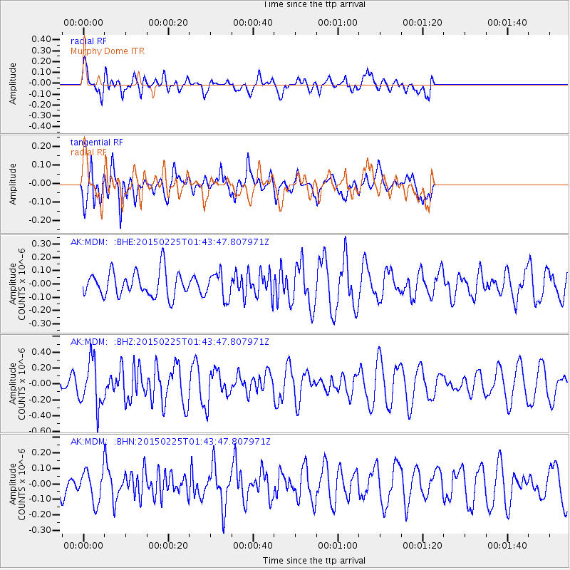
MDM Murphy Dome - Earthquake Result Viewer
*The percent match for this event was below the threshold and hence no stack was calculated.
| Earthquake location: |
Sulu Sea |
| Earthquake latitude/longitude: |
6.1/119.8 |
| Earthquake time(UTC): |
2015/02/25 (056) 01:31:43 GMT |
| Earthquake Depth: |
19 km |
| Earthquake Magnitude: |
5.5 MB |
| Earthquake Catalog/Contributor: |
NEIC PDE/NEIC ALERT |
|
| Network: |
AK Alaska Regional Network |
| Station: |
MDM Murphy Dome |
| Lat/Lon: |
64.96 N/148.23 W |
| Elevation: |
634 m |
|
| Distance: |
85.3 deg |
| Az: |
25.263 deg |
| Baz: |
274.328 deg |
| Ray Param: |
$rayparam |
*The percent match for this event was below the threshold and hence was not used in the summary stack. |
|
| Radial Match: |
65.05168 % |
| Radial Bump: |
400 |
| Transverse Match: |
59.96781 % |
| Transverse Bump: |
400 |
| SOD ConfigId: |
7019011 |
| Insert Time: |
2019-04-17 01:45:08.648 +0000 |
| GWidth: |
2.5 |
| Max Bumps: |
400 |
| Tol: |
0.001 |
|
Signal To Noise
| Channel | StoN | STA | LTA |
| AK:MDM: :BHZ:20150225T01:43:47.807971Z | 3.7693293 | 2.965714E-7 | 7.868015E-8 |
| AK:MDM: :BHN:20150225T01:43:47.807971Z | 0.94743407 | 1.0435109E-7 | 1.1014074E-7 |
| AK:MDM: :BHE:20150225T01:43:47.807971Z | 1.048325 | 9.8394686E-8 | 9.385895E-8 |
| Arrivals |
| Ps | |
| PpPs | |
| PsPs/PpSs | |


