You are here: Home > Network List > UW - Pacific Northwest Regional Seismic Network Stations List
> Station GNW Green Mountain (BB) > Earthquake Result Viewer
GNW Green Mountain (BB) - Earthquake Result Viewer
| Earthquake location: |
E. Caroline Islands, Micronesia |
| Earthquake latitude/longitude: |
6.5/144.9 |
| Earthquake time(UTC): |
2014/05/15 (135) 08:16:34 GMT |
| Earthquake Depth: |
10 km |
| Earthquake Magnitude: |
6.6 MWP, 6.6 MI |
| Earthquake Catalog/Contributor: |
NEIC PDE/NEIC COMCAT |
|
| Network: |
UW Pacific Northwest Regional Seismic Network |
| Station: |
GNW Green Mountain (BB) |
| Lat/Lon: |
47.56 N/122.83 W |
| Elevation: |
160 m |
|
| Distance: |
86.8 deg |
| Az: |
42.669 deg |
| Baz: |
276.053 deg |
| Ray Param: |
0.043801375 |
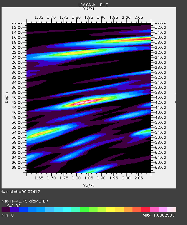
| Estimated Moho Depth: |
41.75 km |
| Estimated Crust Vp/Vs: |
1.83 |
| Assumed Crust Vp: |
6.566 km/s |
| Estimated Crust Vs: |
3.588 km/s |
| Estimated Crust Poisson's Ratio: |
0.29 |
|
| Radial Match: |
90.07412 % |
| Radial Bump: |
400 |
| Transverse Match: |
78.23321 % |
| Transverse Bump: |
400 |
| SOD ConfigId: |
626651 |
| Insert Time: |
2014-05-29 08:53:11.347 +0000 |
| GWidth: |
2.5 |
| Max Bumps: |
400 |
| Tol: |
0.001 |
|
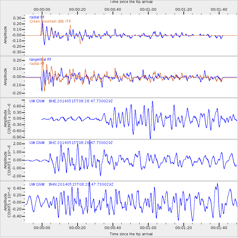
Signal To Noise
| Channel | StoN | STA | LTA |
| UW:GNW: :BHZ:20140515T08:28:47.730029Z | 4.9574766 | 2.5567857E-7 | 5.157434E-8 |
| UW:GNW: :BHN:20140515T08:28:47.730029Z | 0.93029577 | 7.827191E-8 | 8.413659E-8 |
| UW:GNW: :BHE:20140515T08:28:47.730029Z | 1.287435 | 6.823356E-8 | 5.2999614E-8 |
| Arrivals |
| Ps | 5.4 SECOND |
| PpPs | 18 SECOND |
| PsPs/PpSs | 23 SECOND |


