You are here: Home > Network List > TA - USArray Transportable Network (new EarthScope stations) Stations List
> Station A21K Barrow, AK, USA > Earthquake Result Viewer
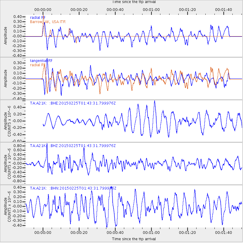
A21K Barrow, AK, USA - Earthquake Result Viewer
*The percent match for this event was below the threshold and hence no stack was calculated.
| Earthquake location: |
Sulu Sea |
| Earthquake latitude/longitude: |
6.1/119.8 |
| Earthquake time(UTC): |
2015/02/25 (056) 01:31:43 GMT |
| Earthquake Depth: |
19 km |
| Earthquake Magnitude: |
5.5 MB |
| Earthquake Catalog/Contributor: |
NEIC PDE/NEIC ALERT |
|
| Network: |
TA USArray Transportable Network (new EarthScope stations) |
| Station: |
A21K Barrow, AK, USA |
| Lat/Lon: |
71.32 N/156.62 W |
| Elevation: |
577 m |
|
| Distance: |
82.2 deg |
| Az: |
18.853 deg |
| Baz: |
265.839 deg |
| Ray Param: |
$rayparam |
*The percent match for this event was below the threshold and hence was not used in the summary stack. |
|
| Radial Match: |
59.71758 % |
| Radial Bump: |
359 |
| Transverse Match: |
59.48871 % |
| Transverse Bump: |
400 |
| SOD ConfigId: |
7019011 |
| Insert Time: |
2019-04-17 01:47:20.764 +0000 |
| GWidth: |
2.5 |
| Max Bumps: |
400 |
| Tol: |
0.001 |
|
Signal To Noise
| Channel | StoN | STA | LTA |
| TA:A21K: :BHZ:20150225T01:43:31.799976Z | 4.804886 | 3.040583E-7 | 6.3281064E-8 |
| TA:A21K: :BHN:20150225T01:43:31.799976Z | 0.91806865 | 1.3390054E-7 | 1.4585025E-7 |
| TA:A21K: :BHE:20150225T01:43:31.799976Z | 1.2761806 | 1.2107256E-7 | 9.487102E-8 |
| Arrivals |
| Ps | |
| PpPs | |
| PsPs/PpSs | |


