You are here: Home > Network List > TA - USArray Transportable Network (new EarthScope stations) Stations List
> Station I23K Minto, Yukon-Koyukuk, AK, USA > Earthquake Result Viewer
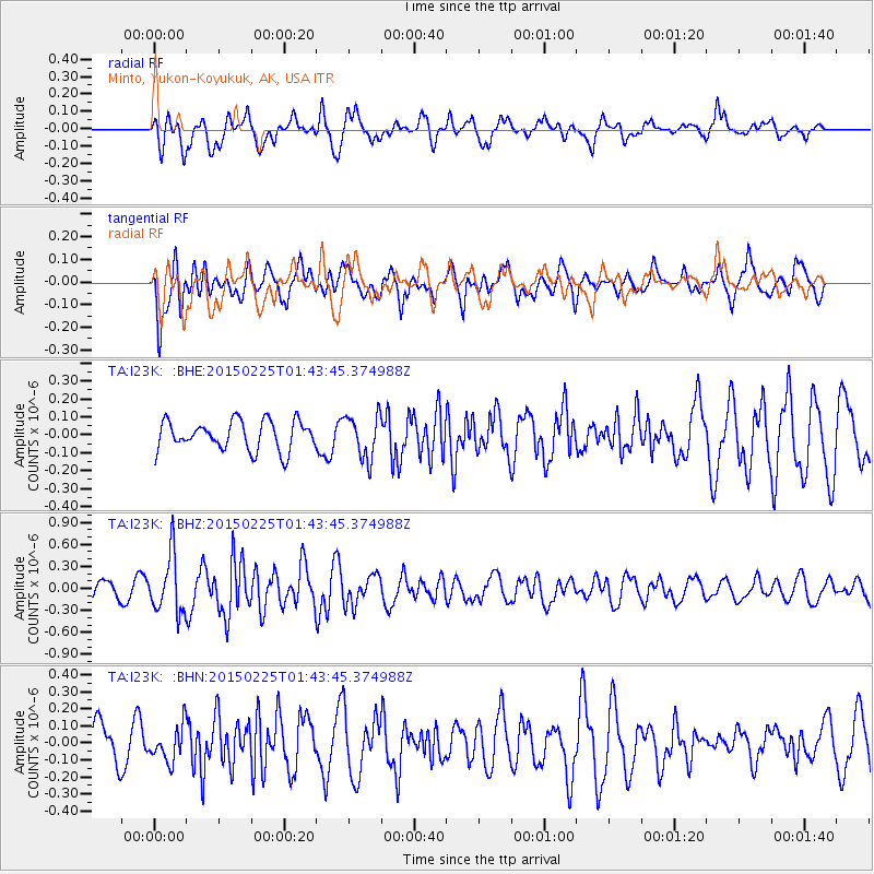
I23K Minto, Yukon-Koyukuk, AK, USA - Earthquake Result Viewer
*The percent match for this event was below the threshold and hence no stack was calculated.
| Earthquake location: |
Sulu Sea |
| Earthquake latitude/longitude: |
6.1/119.8 |
| Earthquake time(UTC): |
2015/02/25 (056) 01:31:43 GMT |
| Earthquake Depth: |
19 km |
| Earthquake Magnitude: |
5.5 MB |
| Earthquake Catalog/Contributor: |
NEIC PDE/NEIC ALERT |
|
| Network: |
TA USArray Transportable Network (new EarthScope stations) |
| Station: |
I23K Minto, Yukon-Koyukuk, AK, USA |
| Lat/Lon: |
65.15 N/149.36 W |
| Elevation: |
149 m |
|
| Distance: |
84.9 deg |
| Az: |
25.105 deg |
| Baz: |
273.29 deg |
| Ray Param: |
$rayparam |
*The percent match for this event was below the threshold and hence was not used in the summary stack. |
|
| Radial Match: |
56.930573 % |
| Radial Bump: |
400 |
| Transverse Match: |
44.821697 % |
| Transverse Bump: |
400 |
| SOD ConfigId: |
7019011 |
| Insert Time: |
2019-04-17 01:47:21.405 +0000 |
| GWidth: |
2.5 |
| Max Bumps: |
400 |
| Tol: |
0.001 |
|
Signal To Noise
| Channel | StoN | STA | LTA |
| TA:I23K: :BHZ:20150225T01:43:45.374988Z | 3.0816576 | 3.9237935E-7 | 1.2732737E-7 |
| TA:I23K: :BHN:20150225T01:43:45.374988Z | 0.6991198 | 1.0100592E-7 | 1.4447583E-7 |
| TA:I23K: :BHE:20150225T01:43:45.374988Z | 1.4592636 | 1.1891836E-7 | 8.149203E-8 |
| Arrivals |
| Ps | |
| PpPs | |
| PsPs/PpSs | |


