You are here: Home > Network List > II - Global Seismograph Network (GSN - IRIS/IDA) Stations List
> Station KURK Kurchatov, Kazakhstan > Earthquake Result Viewer
KURK Kurchatov, Kazakhstan - Earthquake Result Viewer

| Earthquake location: |
Solomon Islands |
| Earthquake latitude/longitude: |
-6.5/155.0 |
| Earthquake time(UTC): |
1996/04/29 (120) 14:40:41 GMT |
| Earthquake Depth: |
44 km |
| Earthquake Magnitude: |
6.3 MB, 7.5 MS, 7.2 UNKNOWN, 6.8 ME |
| Earthquake Catalog/Contributor: |
WHDF/NEIC |
|
| Network: |
II Global Seismograph Network (GSN - IRIS/IDA) |
| Station: |
KURK Kurchatov, Kazakhstan |
| Lat/Lon: |
50.72 N/78.62 E |
| Elevation: |
184 m |
|
| Distance: |
86.5 deg |
| Az: |
321.755 deg |
| Baz: |
104.643 deg |
| Ray Param: |
0.043965746 |
| Estimated Moho Depth: |
40.5 km |
| Estimated Crust Vp/Vs: |
1.88 |
| Assumed Crust Vp: |
6.552 km/s |
| Estimated Crust Vs: |
3.49 km/s |
| Estimated Crust Poisson's Ratio: |
0.30 |
|
| Radial Match: |
98.56385 % |
| Radial Bump: |
285 |
| Transverse Match: |
93.670685 % |
| Transverse Bump: |
400 |
| SOD ConfigId: |
6273 |
| Insert Time: |
2010-03-01 22:15:20.067 +0000 |
| GWidth: |
2.5 |
| Max Bumps: |
400 |
| Tol: |
0.001 |
|
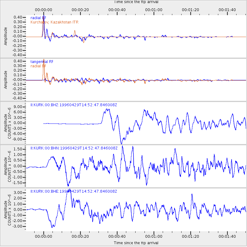
Signal To Noise
| Channel | StoN | STA | LTA |
| II:KURK:00:BHN:19960429T14:52:47.846008Z | 10.238023 | 4.8172313E-7 | 4.705236E-8 |
| II:KURK:00:BHE:19960429T14:52:47.846008Z | 24.3489 | 1.5098751E-6 | 6.2009995E-8 |
| II:KURK:00:BHZ:19960429T14:52:47.846008Z | 38.08199 | 4.578142E-6 | 1.2021803E-7 |
| Arrivals |
| Ps | 5.5 SECOND |
| PpPs | 17 SECOND |
| PsPs/PpSs | 23 SECOND |


