You are here: Home > Network List > II - Global Seismograph Network (GSN - IRIS/IDA) Stations List
> Station KURK Kurchatov, Kazakhstan > Earthquake Result Viewer
KURK Kurchatov, Kazakhstan - Earthquake Result Viewer

| Earthquake location: |
Samar, Philippines |
| Earthquake latitude/longitude: |
12.6/125.2 |
| Earthquake time(UTC): |
1996/06/11 (163) 18:22:55 GMT |
| Earthquake Depth: |
33 km |
| Earthquake Magnitude: |
6.0 MB, 7.0 MS, 7.2 UNKNOWN, 7.1 MW |
| Earthquake Catalog/Contributor: |
WHDF/NEIC |
|
| Network: |
II Global Seismograph Network (GSN - IRIS/IDA) |
| Station: |
KURK Kurchatov, Kazakhstan |
| Lat/Lon: |
50.72 N/78.62 E |
| Elevation: |
184 m |
|
| Distance: |
53.5 deg |
| Az: |
324.988 deg |
| Baz: |
118.234 deg |
| Ray Param: |
0.065975875 |
| Estimated Moho Depth: |
37.25 km |
| Estimated Crust Vp/Vs: |
1.84 |
| Assumed Crust Vp: |
6.552 km/s |
| Estimated Crust Vs: |
3.556 km/s |
| Estimated Crust Poisson's Ratio: |
0.29 |
|
| Radial Match: |
98.697975 % |
| Radial Bump: |
220 |
| Transverse Match: |
73.63007 % |
| Transverse Bump: |
400 |
| SOD ConfigId: |
6273 |
| Insert Time: |
2010-03-01 22:15:30.604 +0000 |
| GWidth: |
2.5 |
| Max Bumps: |
400 |
| Tol: |
0.001 |
|
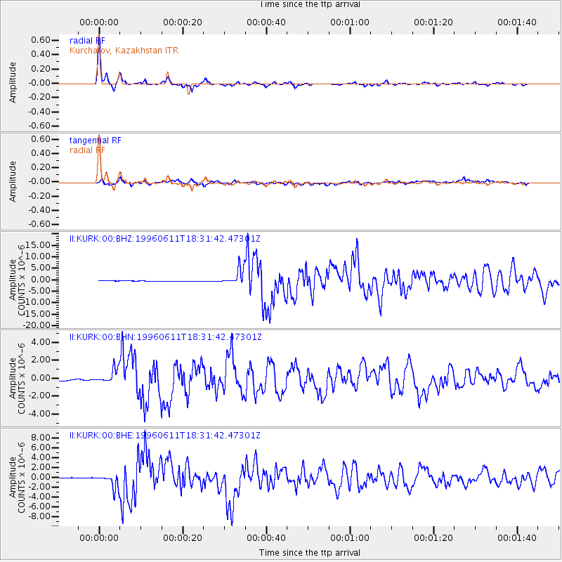
Signal To Noise
| Channel | StoN | STA | LTA |
| II:KURK:00:BHN:19960611T18:31:42.47301Z | 1.1061355 | 7.189824E-7 | 6.499949E-7 |
| II:KURK:00:BHE:19960611T18:31:42.47301Z | 9.767248 | 1.5324177E-6 | 1.568935E-7 |
| II:KURK:00:BHZ:19960611T18:31:42.47301Z | 46.57894 | 3.5798528E-6 | 7.6855606E-8 |
| Arrivals |
| Ps | 5.1 SECOND |
| PpPs | 15 SECOND |
| PsPs/PpSs | 20 SECOND |


