You are here: Home > Network List > II - Global Seismograph Network (GSN - IRIS/IDA) Stations List
> Station KURK Kurchatov, Kazakhstan > Earthquake Result Viewer
KURK Kurchatov, Kazakhstan - Earthquake Result Viewer

| Earthquake location: |
Flores Sea |
| Earthquake latitude/longitude: |
-7.1/122.6 |
| Earthquake time(UTC): |
1996/06/17 (169) 11:22:18 GMT |
| Earthquake Depth: |
587 km |
| Earthquake Magnitude: |
6.6 MB, 7.9 UNKNOWN, 7.8 MW |
| Earthquake Catalog/Contributor: |
WHDF/NEIC |
|
| Network: |
II Global Seismograph Network (GSN - IRIS/IDA) |
| Station: |
KURK Kurchatov, Kazakhstan |
| Lat/Lon: |
50.72 N/78.62 E |
| Elevation: |
184 m |
|
| Distance: |
69.0 deg |
| Az: |
331.781 deg |
| Baz: |
132.431 deg |
| Ray Param: |
0.053882394 |
| Estimated Moho Depth: |
41.25 km |
| Estimated Crust Vp/Vs: |
1.78 |
| Assumed Crust Vp: |
6.552 km/s |
| Estimated Crust Vs: |
3.676 km/s |
| Estimated Crust Poisson's Ratio: |
0.27 |
|
| Radial Match: |
98.52749 % |
| Radial Bump: |
340 |
| Transverse Match: |
94.77673 % |
| Transverse Bump: |
400 |
| SOD ConfigId: |
6273 |
| Insert Time: |
2010-03-01 22:15:35.187 +0000 |
| GWidth: |
2.5 |
| Max Bumps: |
400 |
| Tol: |
0.001 |
|
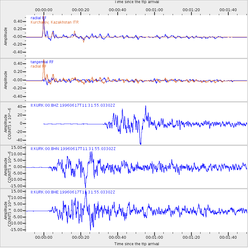
Signal To Noise
| Channel | StoN | STA | LTA |
| II:KURK:00:BHN:19960617T11:31:55.03302Z | 16.95442 | 7.352749E-7 | 4.336774E-8 |
| II:KURK:00:BHE:19960617T11:31:55.03302Z | 34.412674 | 8.5852764E-7 | 2.4948006E-8 |
| II:KURK:00:BHZ:19960617T11:31:55.03302Z | 49.48583 | 2.9652538E-6 | 5.992127E-8 |
| Arrivals |
| Ps | 5.1 SECOND |
| PpPs | 17 SECOND |
| PsPs/PpSs | 22 SECOND |


