You are here: Home > Network List > TA - USArray Transportable Network (new EarthScope stations) Stations List
> Station HDA Harding Lake, AK, USA > Earthquake Result Viewer
HDA Harding Lake, AK, USA - Earthquake Result Viewer

| Earthquake location: |
Negros, Philippines |
| Earthquake latitude/longitude: |
9.4/122.2 |
| Earthquake time(UTC): |
2014/05/15 (135) 10:16:46 GMT |
| Earthquake Depth: |
53 km |
| Earthquake Magnitude: |
6.2 MWP |
| Earthquake Catalog/Contributor: |
NEIC PDE/NEIC COMCAT |
|
| Network: |
TA USArray Transportable Network (new EarthScope stations) |
| Station: |
HDA Harding Lake, AK, USA |
| Lat/Lon: |
64.41 N/146.95 W |
| Elevation: |
437 m |
|
| Distance: |
82.0 deg |
| Az: |
26.012 deg |
| Baz: |
274.888 deg |
| Ray Param: |
0.047121435 |
| Estimated Moho Depth: |
33.25 km |
| Estimated Crust Vp/Vs: |
1.65 |
| Assumed Crust Vp: |
6.566 km/s |
| Estimated Crust Vs: |
3.98 km/s |
| Estimated Crust Poisson's Ratio: |
0.21 |
|
| Radial Match: |
82.82178 % |
| Radial Bump: |
400 |
| Transverse Match: |
82.61648 % |
| Transverse Bump: |
400 |
| SOD ConfigId: |
626651 |
| Insert Time: |
2014-05-29 10:47:35.198 +0000 |
| GWidth: |
2.5 |
| Max Bumps: |
400 |
| Tol: |
0.001 |
|
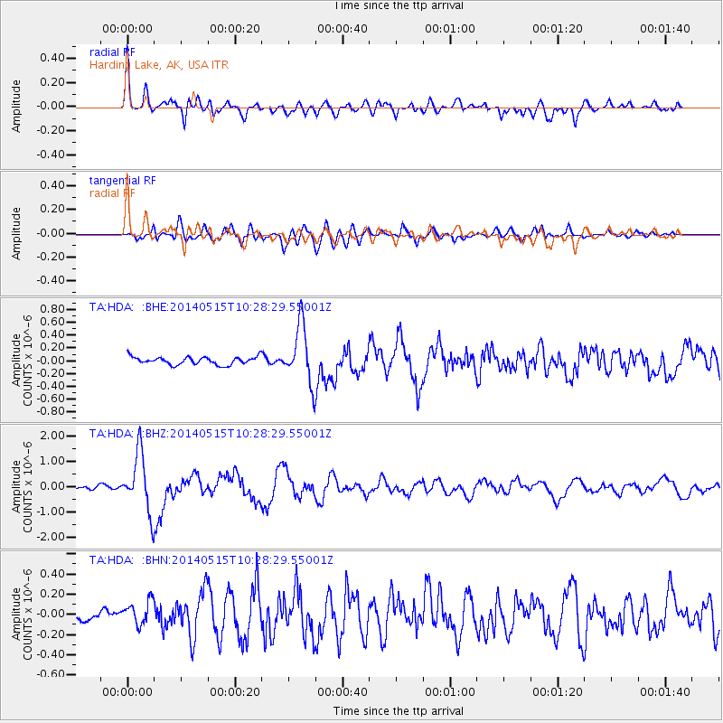
Signal To Noise
| Channel | StoN | STA | LTA |
| TA:HDA: :BHZ:20140515T10:28:29.55001Z | 22.044292 | 1.176323E-6 | 5.33618E-8 |
| TA:HDA: :BHN:20140515T10:28:29.55001Z | 2.1986964 | 1.2640159E-7 | 5.7489334E-8 |
| TA:HDA: :BHE:20140515T10:28:29.55001Z | 7.640665 | 4.538751E-7 | 5.940256E-8 |
| Arrivals |
| Ps | 3.4 SECOND |
| PpPs | 13 SECOND |
| PsPs/PpSs | 16 SECOND |


