You are here: Home > Network List > II - Global Seismograph Network (GSN - IRIS/IDA) Stations List
> Station WRAB Tennant Creek, NT, Australia > Earthquake Result Viewer
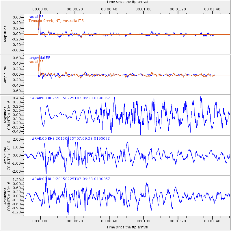
WRAB Tennant Creek, NT, Australia - Earthquake Result Viewer
*The percent match for this event was below the threshold and hence no stack was calculated.
| Earthquake location: |
Southeast Of Honshu, Japan |
| Earthquake latitude/longitude: |
31.1/141.9 |
| Earthquake time(UTC): |
2015/02/25 (056) 07:01:01 GMT |
| Earthquake Depth: |
10 km |
| Earthquake Magnitude: |
5.7 MB |
| Earthquake Catalog/Contributor: |
NEIC PDE/NEIC COMCAT |
|
| Network: |
II Global Seismograph Network (GSN - IRIS/IDA) |
| Station: |
WRAB Tennant Creek, NT, Australia |
| Lat/Lon: |
19.93 S/134.36 E |
| Elevation: |
366 m |
|
| Distance: |
51.2 deg |
| Az: |
189.055 deg |
| Baz: |
8.251 deg |
| Ray Param: |
$rayparam |
*The percent match for this event was below the threshold and hence was not used in the summary stack. |
|
| Radial Match: |
76.43144 % |
| Radial Bump: |
321 |
| Transverse Match: |
57.844097 % |
| Transverse Bump: |
400 |
| SOD ConfigId: |
7019011 |
| Insert Time: |
2019-04-17 01:56:32.058 +0000 |
| GWidth: |
2.5 |
| Max Bumps: |
400 |
| Tol: |
0.001 |
|
Signal To Noise
| Channel | StoN | STA | LTA |
| II:WRAB:00:BHZ:20150225T07:09:33.019005Z | 4.8402967 | 9.0462515E-7 | 1.8689457E-7 |
| II:WRAB:00:BH1:20150225T07:09:33.019005Z | 5.2135987 | 5.915958E-7 | 1.1347167E-7 |
| II:WRAB:00:BH2:20150225T07:09:33.019005Z | 1.1316429 | 1.1078229E-7 | 9.78951E-8 |
| Arrivals |
| Ps | |
| PpPs | |
| PsPs/PpSs | |


