You are here: Home > Network List > II - Global Seismograph Network (GSN - IRIS/IDA) Stations List
> Station PFO Pinon Flat, California, USA > Earthquake Result Viewer
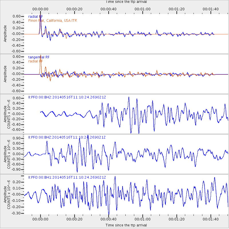
PFO Pinon Flat, California, USA - Earthquake Result Viewer
*The percent match for this event was below the threshold and hence no stack was calculated.
| Earthquake location: |
Leeward Islands |
| Earthquake latitude/longitude: |
17.1/-60.4 |
| Earthquake time(UTC): |
2014/05/16 (136) 11:01:42 GMT |
| Earthquake Depth: |
24 km |
| Earthquake Magnitude: |
6.0 MWP, 6.0 MI |
| Earthquake Catalog/Contributor: |
NEIC PDE/NEIC COMCAT |
|
| Network: |
II Global Seismograph Network (GSN - IRIS/IDA) |
| Station: |
PFO Pinon Flat, California, USA |
| Lat/Lon: |
33.61 N/116.46 W |
| Elevation: |
1280 m |
|
| Distance: |
52.7 deg |
| Az: |
299.449 deg |
| Baz: |
93.639 deg |
| Ray Param: |
$rayparam |
*The percent match for this event was below the threshold and hence was not used in the summary stack. |
|
| Radial Match: |
78.404106 % |
| Radial Bump: |
400 |
| Transverse Match: |
65.800674 % |
| Transverse Bump: |
400 |
| SOD ConfigId: |
626651 |
| Insert Time: |
2014-05-30 11:42:26.680 +0000 |
| GWidth: |
2.5 |
| Max Bumps: |
400 |
| Tol: |
0.001 |
|
Signal To Noise
| Channel | StoN | STA | LTA |
| II:PFO:00:BHZ:20140516T11:10:24.269021Z | 3.2262282 | 2.4529743E-7 | 7.603226E-8 |
| II:PFO:00:BH1:20140516T11:10:24.269021Z | 1.2949992 | 7.605957E-8 | 5.8733296E-8 |
| II:PFO:00:BH2:20140516T11:10:24.269021Z | 2.6645055 | 1.5231772E-7 | 5.7165476E-8 |
| Arrivals |
| Ps | |
| PpPs | |
| PsPs/PpSs | |


