You are here: Home > Network List > TA - USArray Transportable Network (new EarthScope stations) Stations List
> Station O03E Paynes Creek, CA, USA > Earthquake Result Viewer
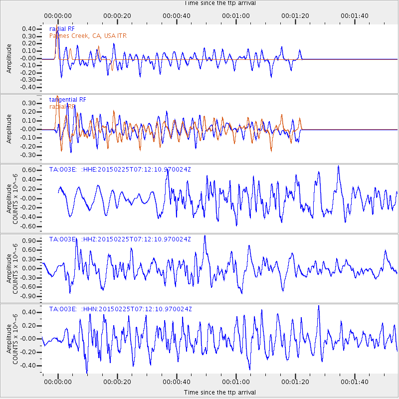
O03E Paynes Creek, CA, USA - Earthquake Result Viewer
*The percent match for this event was below the threshold and hence no stack was calculated.
| Earthquake location: |
Southeast Of Honshu, Japan |
| Earthquake latitude/longitude: |
31.1/141.9 |
| Earthquake time(UTC): |
2015/02/25 (056) 07:01:01 GMT |
| Earthquake Depth: |
10 km |
| Earthquake Magnitude: |
5.7 MB |
| Earthquake Catalog/Contributor: |
NEIC PDE/NEIC COMCAT |
|
| Network: |
TA USArray Transportable Network (new EarthScope stations) |
| Station: |
O03E Paynes Creek, CA, USA |
| Lat/Lon: |
40.29 N/121.80 W |
| Elevation: |
967 m |
|
| Distance: |
75.0 deg |
| Az: |
51.899 deg |
| Baz: |
298.035 deg |
| Ray Param: |
$rayparam |
*The percent match for this event was below the threshold and hence was not used in the summary stack. |
|
| Radial Match: |
70.23302 % |
| Radial Bump: |
400 |
| Transverse Match: |
57.647785 % |
| Transverse Bump: |
400 |
| SOD ConfigId: |
7019011 |
| Insert Time: |
2019-04-17 01:59:23.307 +0000 |
| GWidth: |
2.5 |
| Max Bumps: |
400 |
| Tol: |
0.001 |
|
Signal To Noise
| Channel | StoN | STA | LTA |
| TA:O03E: :HHZ:20150225T07:12:10.970024Z | 2.2884958 | 2.893239E-7 | 1.2642536E-7 |
| TA:O03E: :HHN:20150225T07:12:10.970024Z | 0.599923 | 7.7423415E-8 | 1.2905558E-7 |
| TA:O03E: :HHE:20150225T07:12:10.970024Z | 1.197033 | 2.0878994E-7 | 1.7442288E-7 |
| Arrivals |
| Ps | |
| PpPs | |
| PsPs/PpSs | |


