You are here: Home > Network List > MX - Mexican National Seismic Network Stations List
> Station ZAIG Zacatecas, Zac, MX > Earthquake Result Viewer
ZAIG Zacatecas, Zac, MX - Earthquake Result Viewer
| Earthquake location: |
Leeward Islands |
| Earthquake latitude/longitude: |
17.1/-60.4 |
| Earthquake time(UTC): |
2014/05/16 (136) 11:01:42 GMT |
| Earthquake Depth: |
24 km |
| Earthquake Magnitude: |
6.0 MWP, 6.0 MI |
| Earthquake Catalog/Contributor: |
NEIC PDE/NEIC COMCAT |
|
| Network: |
MX Mexican National Seismic Network |
| Station: |
ZAIG Zacatecas, Zac, MX |
| Lat/Lon: |
22.77 N/102.57 W |
| Elevation: |
2408 m |
|
| Distance: |
40.0 deg |
| Az: |
285.194 deg |
| Baz: |
90.287 deg |
| Ray Param: |
0.0746381 |
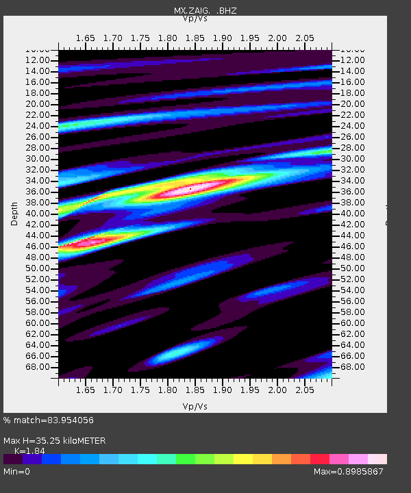
| Estimated Moho Depth: |
35.25 km |
| Estimated Crust Vp/Vs: |
1.84 |
| Assumed Crust Vp: |
6.597 km/s |
| Estimated Crust Vs: |
3.586 km/s |
| Estimated Crust Poisson's Ratio: |
0.29 |
|
| Radial Match: |
83.954056 % |
| Radial Bump: |
396 |
| Transverse Match: |
66.24462 % |
| Transverse Bump: |
400 |
| SOD ConfigId: |
626651 |
| Insert Time: |
2014-05-30 11:46:28.365 +0000 |
| GWidth: |
2.5 |
| Max Bumps: |
400 |
| Tol: |
0.001 |
|

Signal To Noise
| Channel | StoN | STA | LTA |
| MX:ZAIG: :BHZ:20140516T11:08:44.555001Z | 3.7169573 | 5.510348E-7 | 1.482489E-7 |
| MX:ZAIG: :BHN:20140516T11:08:44.555001Z | 0.63465375 | 6.3980345E-8 | 1.0081142E-7 |
| MX:ZAIG: :BHE:20140516T11:08:44.555001Z | 2.652379 | 2.7188224E-7 | 1.0250505E-7 |
| Arrivals |
| Ps | 4.8 SECOND |
| PpPs | 14 SECOND |
| PsPs/PpSs | 19 SECOND |


