You are here: Home > Network List > XL12 - Hangay Dome, Mongolia Stations List
> Station HV31 HV31 > Earthquake Result Viewer
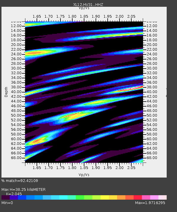
HV31 HV31 - Earthquake Result Viewer
| Earthquake location: |
Southeast Of Honshu, Japan |
| Earthquake latitude/longitude: |
31.1/141.9 |
| Earthquake time(UTC): |
2015/02/25 (056) 07:01:01 GMT |
| Earthquake Depth: |
10 km |
| Earthquake Magnitude: |
5.7 MB |
| Earthquake Catalog/Contributor: |
NEIC PDE/NEIC COMCAT |
|
| Network: |
XL Hangay Dome, Mongolia |
| Station: |
HV31 HV31 |
| Lat/Lon: |
51.34 N/100.24 E |
| Elevation: |
1693 m |
|
| Distance: |
36.6 deg |
| Az: |
315.719 deg |
| Baz: |
107.282 deg |
| Ray Param: |
0.07657598 |
| Estimated Moho Depth: |
38.25 km |
| Estimated Crust Vp/Vs: |
2.05 |
| Assumed Crust Vp: |
6.419 km/s |
| Estimated Crust Vs: |
3.139 km/s |
| Estimated Crust Poisson's Ratio: |
0.34 |
|
| Radial Match: |
92.42109 % |
| Radial Bump: |
400 |
| Transverse Match: |
82.44832 % |
| Transverse Bump: |
400 |
| SOD ConfigId: |
7019011 |
| Insert Time: |
2019-04-17 02:01:18.599 +0000 |
| GWidth: |
2.5 |
| Max Bumps: |
400 |
| Tol: |
0.001 |
|

Signal To Noise
| Channel | StoN | STA | LTA |
| XL:HV31: :HHZ:20150225T07:07:36.629998Z | 20.893284 | 1.3296756E-6 | 6.3641295E-8 |
| XL:HV31: :HHN:20150225T07:07:36.629998Z | 4.1759286 | 3.437308E-7 | 8.231242E-8 |
| XL:HV31: :HHE:20150225T07:07:36.629998Z | 14.456018 | 1.3316969E-6 | 9.212058E-8 |
| Arrivals |
| Ps | 6.6 SECOND |
| PpPs | 17 SECOND |
| PsPs/PpSs | 24 SECOND |


