You are here: Home > Network List > N4 - Central and EAstern US Network Stations List
> Station T42B Van Buren, MO, USA > Earthquake Result Viewer
T42B Van Buren, MO, USA - Earthquake Result Viewer
| Earthquake location: |
Leeward Islands |
| Earthquake latitude/longitude: |
17.1/-60.4 |
| Earthquake time(UTC): |
2014/05/16 (136) 11:01:42 GMT |
| Earthquake Depth: |
24 km |
| Earthquake Magnitude: |
6.0 MWP, 6.0 MI |
| Earthquake Catalog/Contributor: |
NEIC PDE/NEIC COMCAT |
|
| Network: |
N4 Central and EAstern US Network |
| Station: |
T42B Van Buren, MO, USA |
| Lat/Lon: |
37.03 N/91.09 W |
| Elevation: |
165 m |
|
| Distance: |
33.6 deg |
| Az: |
312.36 deg |
| Baz: |
117.981 deg |
| Ray Param: |
0.07811416 |
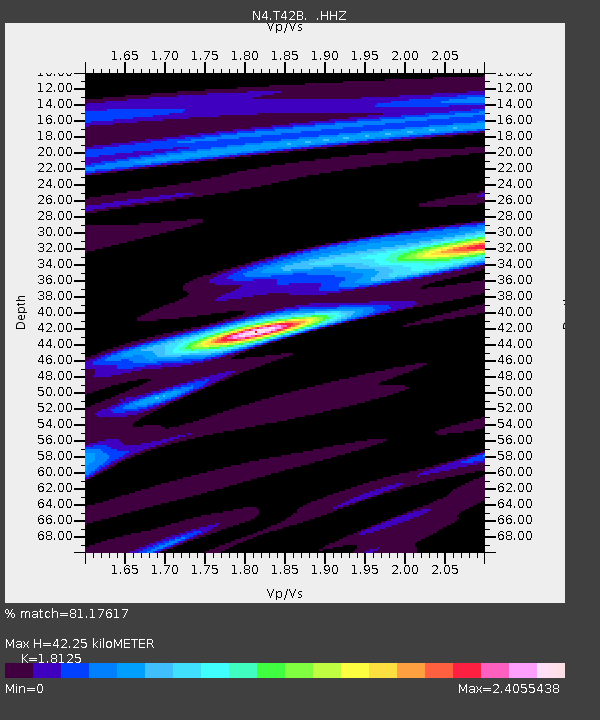
| Estimated Moho Depth: |
42.25 km |
| Estimated Crust Vp/Vs: |
1.81 |
| Assumed Crust Vp: |
6.53 km/s |
| Estimated Crust Vs: |
3.603 km/s |
| Estimated Crust Poisson's Ratio: |
0.28 |
|
| Radial Match: |
81.17617 % |
| Radial Bump: |
358 |
| Transverse Match: |
54.101414 % |
| Transverse Bump: |
400 |
| SOD ConfigId: |
626651 |
| Insert Time: |
2014-05-30 11:49:19.171 +0000 |
| GWidth: |
2.5 |
| Max Bumps: |
400 |
| Tol: |
0.001 |
|

Signal To Noise
| Channel | StoN | STA | LTA |
| N4:T42B: :HHZ:20140516T11:07:50.350015Z | 1.9293714 | 1.2573351E-7 | 6.516812E-8 |
| N4:T42B: :HHN:20140516T11:07:50.350015Z | 1.3766612 | 1.1451319E-7 | 8.318183E-8 |
| N4:T42B: :HHE:20140516T11:07:50.350015Z | 1.9232726 | 1.5916909E-7 | 8.2759506E-8 |
| Arrivals |
| Ps | 5.7 SECOND |
| PpPs | 17 SECOND |
| PsPs/PpSs | 23 SECOND |


