You are here: Home > Network List > NI - North-East Italy Broadband Network Stations List
> Station FUSE Fusea > Earthquake Result Viewer
FUSE Fusea - Earthquake Result Viewer
| Earthquake location: |
Leeward Islands |
| Earthquake latitude/longitude: |
17.1/-60.4 |
| Earthquake time(UTC): |
2014/05/16 (136) 11:01:42 GMT |
| Earthquake Depth: |
24 km |
| Earthquake Magnitude: |
6.0 MWP, 6.0 MI |
| Earthquake Catalog/Contributor: |
NEIC PDE/NEIC COMCAT |
|
| Network: |
NI North-East Italy Broadband Network |
| Station: |
FUSE Fusea |
| Lat/Lon: |
46.41 N/13.00 E |
| Elevation: |
574 m |
|
| Distance: |
66.4 deg |
| Az: |
46.335 deg |
| Baz: |
270.291 deg |
| Ray Param: |
0.05759476 |
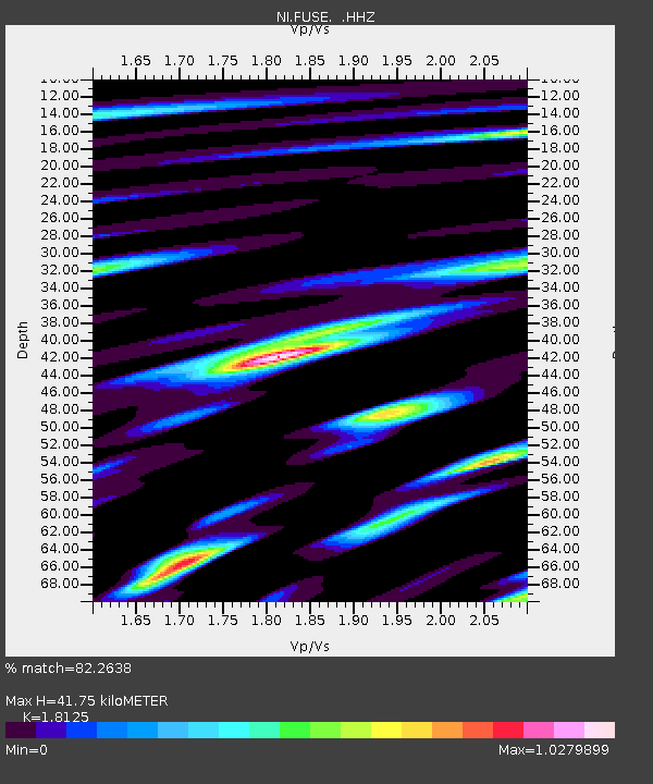
| Estimated Moho Depth: |
41.75 km |
| Estimated Crust Vp/Vs: |
1.81 |
| Assumed Crust Vp: |
6.35 km/s |
| Estimated Crust Vs: |
3.503 km/s |
| Estimated Crust Poisson's Ratio: |
0.28 |
|
| Radial Match: |
82.2638 % |
| Radial Bump: |
400 |
| Transverse Match: |
72.81139 % |
| Transverse Bump: |
400 |
| SOD ConfigId: |
626651 |
| Insert Time: |
2014-05-30 11:50:27.064 +0000 |
| GWidth: |
2.5 |
| Max Bumps: |
400 |
| Tol: |
0.001 |
|

Signal To Noise
| Channel | StoN | STA | LTA |
| NI:FUSE: :HHZ:20140516T11:11:58.907998Z | 15.290238 | 8.954824E-7 | 5.8565625E-8 |
| NI:FUSE: :HHN:20140516T11:11:58.907998Z | 3.1744452 | 2.3467065E-7 | 7.392494E-8 |
| NI:FUSE: :HHE:20140516T11:11:58.907998Z | 7.2004595 | 3.6470038E-7 | 5.0649597E-8 |
| Arrivals |
| Ps | 5.6 SECOND |
| PpPs | 18 SECOND |
| PsPs/PpSs | 23 SECOND |


