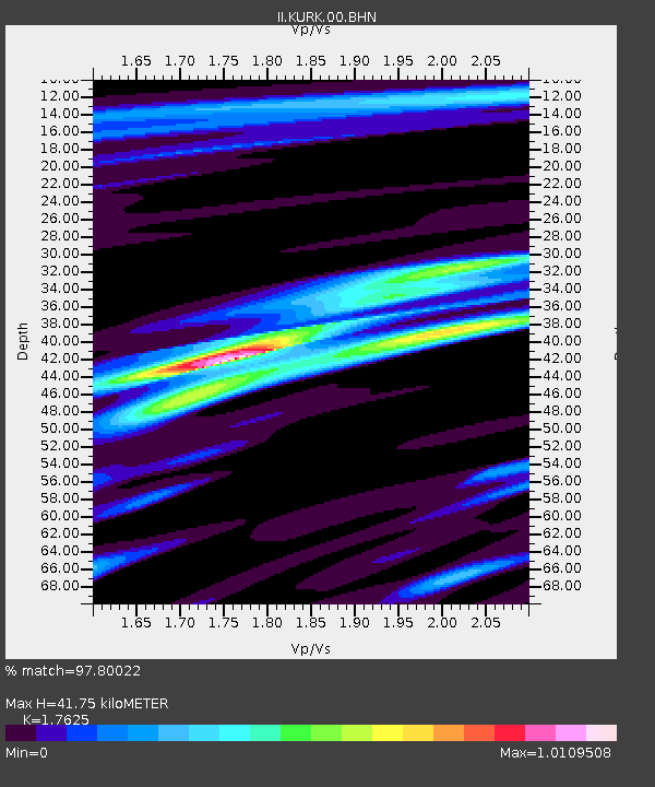
KURK Kurchatov, Kazakhstan - Earthquake Result Viewer
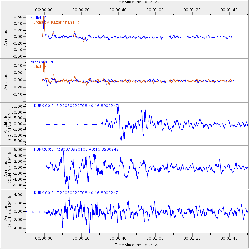
Earthquake location: Southern Sumatra, Indonesia
Earthquake latitude/longitude: -2.0/100.1
Earthquake time(UTC): 2007/09/20 (263) 08:31:14 GMT
Earthquake Depth: 30 km
Earthquake Magnitude: 6.3 MB, 6.8 MS, 6.7 MW, 6.3 ME
Earthquake Catalog/Contributor: WHDF/NEIC
Network: II Global Seismograph Network (GSN - IRIS/IDA)
Station: KURK Kurchatov, Kazakhstan
Lat/Lon: 50.72 N/78.62 E
Elevation: 184 m
Distance: 55.6 deg
Az: 343.592 deg
Baz: 153.636 deg
Ray Param: 0.064606346
Estimated Moho Depth: 41.75 km
Estimated Crust Vp/Vs: 1.76
Assumed Crust Vp: 6.552 km/s
Estimated Crust Vs: 3.718 km/s
Estimated Crust Poisson's Ratio: 0.26
Radial Match: 97.80022 %
Radial Bump: 273
Transverse Match: 94.96925 %
Transverse Bump: 400
SOD ConfigId: 2564
Insert Time: 2010-03-01 22:17:27.550 +0000
GWidth: 2.5
Max Bumps: 400
Tol: 0.001

Signal To Noise

ChannelStoNSTALTA
II:KURK:00:BHN:20070920T08:40:16.890024Z18.9401976.545917E-73.456098E-8
II:KURK:00:BHE:20070920T08:40:16.890024Z11.7619963.3624661E-72.8587548E-8
II:KURK:00:BHZ:20070920T08:40:16.890024Z26.239511.6297868E-66.211194E-8
Arrivals
Ps5.1 SECOND
PpPs17 SECOND
PsPs/PpSs22 SECOND