You are here: Home > Network List > TA - USArray Transportable Network (new EarthScope stations) Stations List
> Station 833A Chaparral WMA, Artesia Wells, TX, USA > Earthquake Result Viewer
833A Chaparral WMA, Artesia Wells, TX, USA - Earthquake Result Viewer
| Earthquake location: |
Leeward Islands |
| Earthquake latitude/longitude: |
17.1/-60.4 |
| Earthquake time(UTC): |
2014/05/16 (136) 11:01:42 GMT |
| Earthquake Depth: |
24 km |
| Earthquake Magnitude: |
6.0 MWP, 6.0 MI |
| Earthquake Catalog/Contributor: |
NEIC PDE/NEIC COMCAT |
|
| Network: |
TA USArray Transportable Network (new EarthScope stations) |
| Station: |
833A Chaparral WMA, Artesia Wells, TX, USA |
| Lat/Lon: |
28.32 N/99.39 W |
| Elevation: |
171 m |
|
| Distance: |
37.5 deg |
| Az: |
294.37 deg |
| Baz: |
98.815 deg |
| Ray Param: |
0.076050416 |
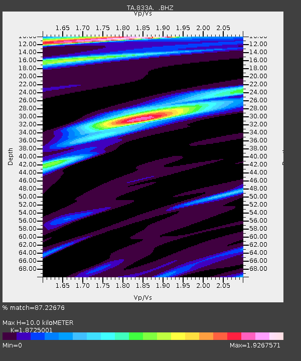
| Estimated Moho Depth: |
10.0 km |
| Estimated Crust Vp/Vs: |
1.87 |
| Assumed Crust Vp: |
6.347 km/s |
| Estimated Crust Vs: |
3.39 km/s |
| Estimated Crust Poisson's Ratio: |
0.30 |
|
| Radial Match: |
87.22676 % |
| Radial Bump: |
384 |
| Transverse Match: |
67.80691 % |
| Transverse Bump: |
400 |
| SOD ConfigId: |
626651 |
| Insert Time: |
2014-05-30 11:56:16.217 +0000 |
| GWidth: |
2.5 |
| Max Bumps: |
400 |
| Tol: |
0.001 |
|

Signal To Noise
| Channel | StoN | STA | LTA |
| TA:833A: :BHZ:20140516T11:08:24.250009Z | 7.5055943 | 7.322257E-7 | 9.755733E-8 |
| TA:833A: :BHN:20140516T11:08:24.250009Z | 1.1457992 | 1.1110523E-7 | 9.696746E-8 |
| TA:833A: :BHE:20140516T11:08:24.250009Z | 2.8272238 | 3.637155E-7 | 1.2864757E-7 |
| Arrivals |
| Ps | 1.5 SECOND |
| PpPs | 4.2 SECOND |
| PsPs/PpSs | 5.7 SECOND |


