You are here: Home > Network List > TA - USArray Transportable Network (new EarthScope stations) Stations List
> Station D54A Lac Fusel, La Vallee-de-La-Gatineau, QC, CAN > Earthquake Result Viewer
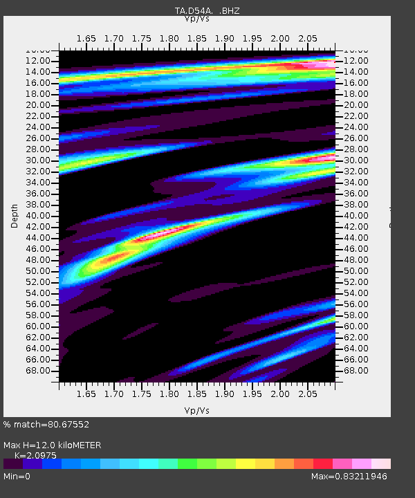
D54A Lac Fusel, La Vallee-de-La-Gatineau, QC, CAN - Earthquake Result Viewer
| Earthquake location: |
Leeward Islands |
| Earthquake latitude/longitude: |
17.1/-60.4 |
| Earthquake time(UTC): |
2014/05/16 (136) 11:01:42 GMT |
| Earthquake Depth: |
24 km |
| Earthquake Magnitude: |
6.0 MWP, 6.0 MI |
| Earthquake Catalog/Contributor: |
NEIC PDE/NEIC COMCAT |
|
| Network: |
TA USArray Transportable Network (new EarthScope stations) |
| Station: |
D54A Lac Fusel, La Vallee-de-La-Gatineau, QC, CAN |
| Lat/Lon: |
47.15 N/76.66 W |
| Elevation: |
415 m |
|
| Distance: |
32.9 deg |
| Az: |
339.365 deg |
| Baz: |
150.407 deg |
| Ray Param: |
0.07844428 |
| Estimated Moho Depth: |
12.0 km |
| Estimated Crust Vp/Vs: |
2.10 |
| Assumed Crust Vp: |
6.622 km/s |
| Estimated Crust Vs: |
3.157 km/s |
| Estimated Crust Poisson's Ratio: |
0.35 |
|
| Radial Match: |
80.67552 % |
| Radial Bump: |
380 |
| Transverse Match: |
60.098614 % |
| Transverse Bump: |
400 |
| SOD ConfigId: |
626651 |
| Insert Time: |
2014-05-30 11:56:56.607 +0000 |
| GWidth: |
2.5 |
| Max Bumps: |
400 |
| Tol: |
0.001 |
|

Signal To Noise
| Channel | StoN | STA | LTA |
| TA:D54A: :BHZ:20140516T11:07:44.125009Z | 2.4094799 | 2.4071252E-7 | 9.990228E-8 |
| TA:D54A: :BHN:20140516T11:07:44.125009Z | 1.3151149 | 1.1964038E-7 | 9.097332E-8 |
| TA:D54A: :BHE:20140516T11:07:44.125009Z | 1.5810795 | 1.423706E-7 | 9.004645E-8 |
| Arrivals |
| Ps | 2.1 SECOND |
| PpPs | 5.2 SECOND |
| PsPs/PpSs | 7.4 SECOND |


