You are here: Home > Network List > TA - USArray Transportable Network (new EarthScope stations) Stations List
> Station N23A Red Feather Lakes, CO, USA > Earthquake Result Viewer
N23A Red Feather Lakes, CO, USA - Earthquake Result Viewer

| Earthquake location: |
Leeward Islands |
| Earthquake latitude/longitude: |
17.1/-60.4 |
| Earthquake time(UTC): |
2014/05/16 (136) 11:01:42 GMT |
| Earthquake Depth: |
24 km |
| Earthquake Magnitude: |
6.0 MWP, 6.0 MI |
| Earthquake Catalog/Contributor: |
NEIC PDE/NEIC COMCAT |
|
| Network: |
TA USArray Transportable Network (new EarthScope stations) |
| Station: |
N23A Red Feather Lakes, CO, USA |
| Lat/Lon: |
40.89 N/105.94 W |
| Elevation: |
2458 m |
|
| Distance: |
45.7 deg |
| Az: |
310.895 deg |
| Baz: |
107.508 deg |
| Ray Param: |
0.07104962 |
| Estimated Moho Depth: |
38.5 km |
| Estimated Crust Vp/Vs: |
1.93 |
| Assumed Crust Vp: |
6.306 km/s |
| Estimated Crust Vs: |
3.272 km/s |
| Estimated Crust Poisson's Ratio: |
0.32 |
|
| Radial Match: |
85.72433 % |
| Radial Bump: |
400 |
| Transverse Match: |
64.11785 % |
| Transverse Bump: |
400 |
| SOD ConfigId: |
626651 |
| Insert Time: |
2014-05-30 12:00:30.014 +0000 |
| GWidth: |
2.5 |
| Max Bumps: |
400 |
| Tol: |
0.001 |
|
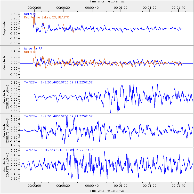
Signal To Noise
| Channel | StoN | STA | LTA |
| TA:N23A: :BHZ:20140516T11:09:31.225015Z | 1.8238628 | 1.7084969E-7 | 9.367464E-8 |
| TA:N23A: :BHN:20140516T11:09:31.225015Z | 1.3702234 | 1.0749914E-7 | 7.845373E-8 |
| TA:N23A: :BHE:20140516T11:09:31.225015Z | 0.97182596 | 9.5544166E-8 | 9.8314075E-8 |
| Arrivals |
| Ps | 6.0 SECOND |
| PpPs | 17 SECOND |
| PsPs/PpSs | 23 SECOND |


