You are here: Home > Network List > CI - Caltech Regional Seismic Network Stations List
> Station SWS Sam W. Stewart, Westmorland, CA, USA > Earthquake Result Viewer
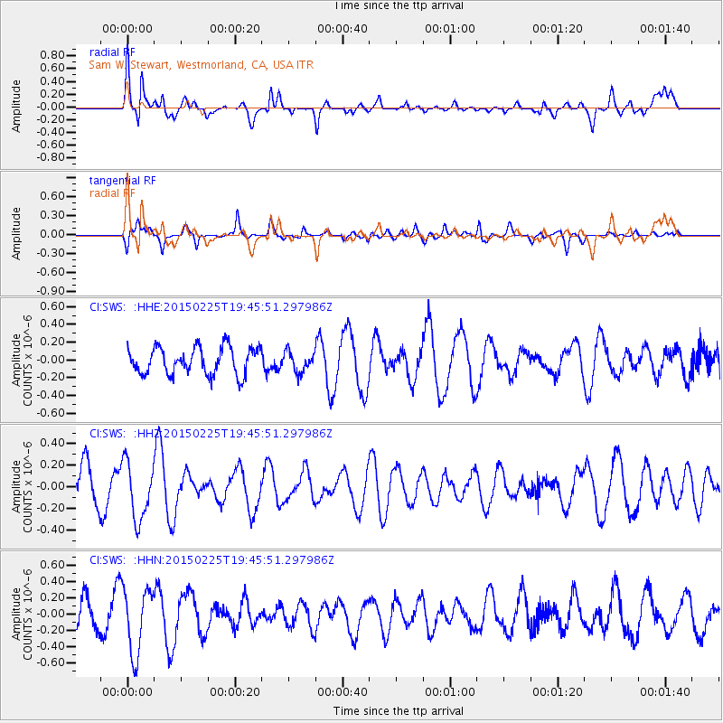
SWS Sam W. Stewart, Westmorland, CA, USA - Earthquake Result Viewer
*The percent match for this event was below the threshold and hence no stack was calculated.
| Earthquake location: |
Off E. Coast Of N. Island, N.Z. |
| Earthquake latitude/longitude: |
-36.6/177.3 |
| Earthquake time(UTC): |
2015/02/25 (056) 19:33:08 GMT |
| Earthquake Depth: |
10 km |
| Earthquake Magnitude: |
5.3 MW |
| Earthquake Catalog/Contributor: |
ISC/ISC |
|
| Network: |
CI Caltech Regional Seismic Network |
| Station: |
SWS Sam W. Stewart, Westmorland, CA, USA |
| Lat/Lon: |
32.94 N/115.80 W |
| Elevation: |
140 m |
|
| Distance: |
93.2 deg |
| Az: |
50.765 deg |
| Baz: |
227.829 deg |
| Ray Param: |
$rayparam |
*The percent match for this event was below the threshold and hence was not used in the summary stack. |
|
| Radial Match: |
69.59551 % |
| Radial Bump: |
400 |
| Transverse Match: |
60.383945 % |
| Transverse Bump: |
400 |
| SOD ConfigId: |
7019011 |
| Insert Time: |
2019-04-17 02:04:45.090 +0000 |
| GWidth: |
2.5 |
| Max Bumps: |
400 |
| Tol: |
0.001 |
|
Signal To Noise
| Channel | StoN | STA | LTA |
| CI:SWS: :HHZ:20150225T19:45:51.297986Z | 1.4714925 | 2.682166E-7 | 1.8227522E-7 |
| CI:SWS: :HHN:20150225T19:45:51.297986Z | 2.581186 | 3.9983138E-7 | 1.549022E-7 |
| CI:SWS: :HHE:20150225T19:45:51.297986Z | 0.7393492 | 1.12281626E-7 | 1.5186549E-7 |
| Arrivals |
| Ps | |
| PpPs | |
| PsPs/PpSs | |


