You are here: Home > Network List > TA - USArray Transportable Network (new EarthScope stations) Stations List
> Station O03E Paynes Creek, CA, USA > Earthquake Result Viewer
O03E Paynes Creek, CA, USA - Earthquake Result Viewer
| Earthquake location: |
Leeward Islands |
| Earthquake latitude/longitude: |
17.1/-60.4 |
| Earthquake time(UTC): |
2014/05/16 (136) 11:01:42 GMT |
| Earthquake Depth: |
24 km |
| Earthquake Magnitude: |
6.0 MWP, 6.0 MI |
| Earthquake Catalog/Contributor: |
NEIC PDE/NEIC COMCAT |
|
| Network: |
TA USArray Transportable Network (new EarthScope stations) |
| Station: |
O03E Paynes Creek, CA, USA |
| Lat/Lon: |
40.29 N/121.80 W |
| Elevation: |
967 m |
|
| Distance: |
57.4 deg |
| Az: |
307.17 deg |
| Baz: |
94.863 deg |
| Ray Param: |
0.06345359 |
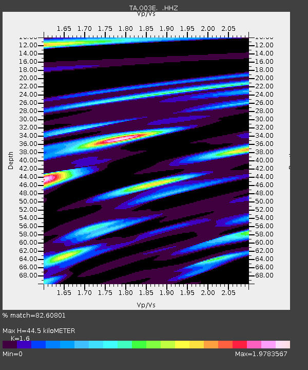
| Estimated Moho Depth: |
44.5 km |
| Estimated Crust Vp/Vs: |
1.60 |
| Assumed Crust Vp: |
6.566 km/s |
| Estimated Crust Vs: |
4.104 km/s |
| Estimated Crust Poisson's Ratio: |
0.18 |
|
| Radial Match: |
82.60801 % |
| Radial Bump: |
400 |
| Transverse Match: |
85.48314 % |
| Transverse Bump: |
345 |
| SOD ConfigId: |
626651 |
| Insert Time: |
2014-05-30 12:00:39.899 +0000 |
| GWidth: |
2.5 |
| Max Bumps: |
400 |
| Tol: |
0.001 |
|
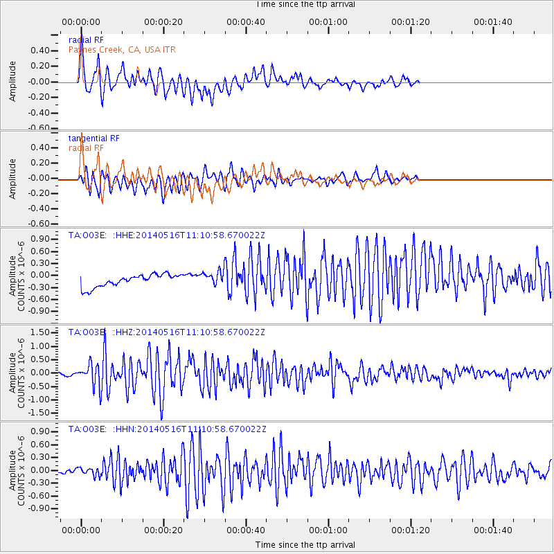
Signal To Noise
| Channel | StoN | STA | LTA |
| TA:O03E: :HHZ:20140516T11:10:58.670022Z | 8.851047 | 4.0055684E-7 | 4.5255305E-8 |
| TA:O03E: :HHN:20140516T11:10:58.670022Z | 1.4014075 | 9.8379196E-8 | 7.020028E-8 |
| TA:O03E: :HHE:20140516T11:10:58.670022Z | 1.1619657 | 1.813538E-7 | 1.5607499E-7 |
| Arrivals |
| Ps | 4.3 SECOND |
| PpPs | 17 SECOND |
| PsPs/PpSs | 21 SECOND |


