You are here: Home > Network List > CI - Caltech Regional Seismic Network Stations List
> Station VCS Vincent Substation, Palmdale, CA, USA > Earthquake Result Viewer
VCS Vincent Substation, Palmdale, CA, USA - Earthquake Result Viewer
| Earthquake location: |
E. Russia-N.E. China Border Reg. |
| Earthquake latitude/longitude: |
43.8/130.7 |
| Earthquake time(UTC): |
2002/06/28 (179) 17:19:30 GMT |
| Earthquake Depth: |
566 km |
| Earthquake Magnitude: |
6.7 MB, 7.3 MW, 7.3 MW |
| Earthquake Catalog/Contributor: |
WHDF/NEIC |
|
| Network: |
CI Caltech Regional Seismic Network |
| Station: |
VCS Vincent Substation, Palmdale, CA, USA |
| Lat/Lon: |
34.48 N/118.12 W |
| Elevation: |
991 m |
|
| Distance: |
80.1 deg |
| Az: |
51.415 deg |
| Baz: |
316.707 deg |
| Ray Param: |
0.046779204 |
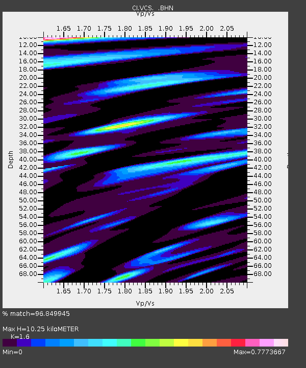
| Estimated Moho Depth: |
10.25 km |
| Estimated Crust Vp/Vs: |
1.60 |
| Assumed Crust Vp: |
6.1 km/s |
| Estimated Crust Vs: |
3.812 km/s |
| Estimated Crust Poisson's Ratio: |
0.18 |
|
| Radial Match: |
96.849945 % |
| Radial Bump: |
400 |
| Transverse Match: |
88.90395 % |
| Transverse Bump: |
400 |
| SOD ConfigId: |
3787 |
| Insert Time: |
2010-02-25 21:05:10.558 +0000 |
| GWidth: |
2.5 |
| Max Bumps: |
400 |
| Tol: |
0.001 |
|
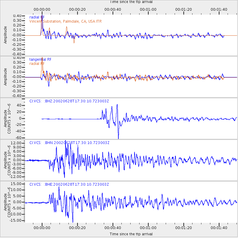
Signal To Noise
| Channel | StoN | STA | LTA |
| CI:VCS: :BHN:20020628T17:30:10.723003Z | 9.454815 | 1.4665983E-6 | 1.5511655E-7 |
| CI:VCS: :BHE:20020628T17:30:10.723003Z | 11.341241 | 1.7494846E-6 | 1.5425866E-7 |
| CI:VCS: :BHZ:20020628T17:30:10.723003Z | 32.985085 | 6.8696218E-6 | 2.082645E-7 |
| Arrivals |
| Ps | 1.0 SECOND |
| PpPs | 4.3 SECOND |
| PsPs/PpSs | 5.3 SECOND |


