You are here: Home > Network List > UW - Pacific Northwest Regional Seismic Network Stations List
> Station MRBL Marblemount, WA, USA > Earthquake Result Viewer
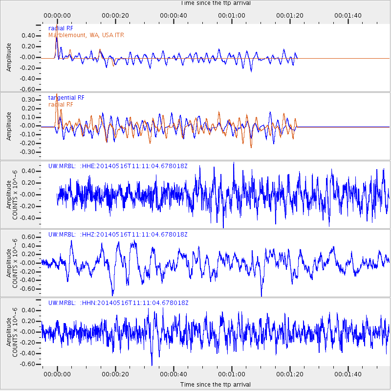
MRBL Marblemount, WA, USA - Earthquake Result Viewer
*The percent match for this event was below the threshold and hence no stack was calculated.
| Earthquake location: |
Leeward Islands |
| Earthquake latitude/longitude: |
17.1/-60.4 |
| Earthquake time(UTC): |
2014/05/16 (136) 11:01:42 GMT |
| Earthquake Depth: |
24 km |
| Earthquake Magnitude: |
6.0 MWP, 6.0 MI |
| Earthquake Catalog/Contributor: |
NEIC PDE/NEIC COMCAT |
|
| Network: |
UW Pacific Northwest Regional Seismic Network |
| Station: |
MRBL Marblemount, WA, USA |
| Lat/Lon: |
48.52 N/121.48 W |
| Elevation: |
75 m |
|
| Distance: |
58.3 deg |
| Az: |
316.834 deg |
| Baz: |
100.234 deg |
| Ray Param: |
$rayparam |
*The percent match for this event was below the threshold and hence was not used in the summary stack. |
|
| Radial Match: |
60.38738 % |
| Radial Bump: |
400 |
| Transverse Match: |
56.29499 % |
| Transverse Bump: |
400 |
| SOD ConfigId: |
626651 |
| Insert Time: |
2014-05-30 12:07:31.454 +0000 |
| GWidth: |
2.5 |
| Max Bumps: |
400 |
| Tol: |
0.001 |
|
Signal To Noise
| Channel | StoN | STA | LTA |
| UW:MRBL: :HHZ:20140516T11:11:04.678018Z | 2.8024287 | 1.7825795E-7 | 6.360838E-8 |
| UW:MRBL: :HHN:20140516T11:11:04.678018Z | 1.0075349 | 1.0983798E-7 | 1.09016554E-7 |
| UW:MRBL: :HHE:20140516T11:11:04.678018Z | 1.0914478 | 1.226873E-7 | 1.12407854E-7 |
| Arrivals |
| Ps | |
| PpPs | |
| PsPs/PpSs | |


