You are here: Home > Network List > ZW13 - Locating North Texas Earthquakes Stations List
> Station AZHL Azle B1 > Earthquake Result Viewer
AZHL Azle B1 - Earthquake Result Viewer
| Earthquake location: |
Leeward Islands |
| Earthquake latitude/longitude: |
17.1/-60.4 |
| Earthquake time(UTC): |
2014/05/16 (136) 11:01:42 GMT |
| Earthquake Depth: |
24 km |
| Earthquake Magnitude: |
6.0 MWP, 6.0 MI |
| Earthquake Catalog/Contributor: |
NEIC PDE/NEIC COMCAT |
|
| Network: |
ZW Locating North Texas Earthquakes |
| Station: |
AZHL Azle B1 |
| Lat/Lon: |
32.97 N/97.35 W |
| Elevation: |
222 m |
|
| Distance: |
36.8 deg |
| Az: |
302.484 deg |
| Baz: |
106.323 deg |
| Ray Param: |
0.07644019 |
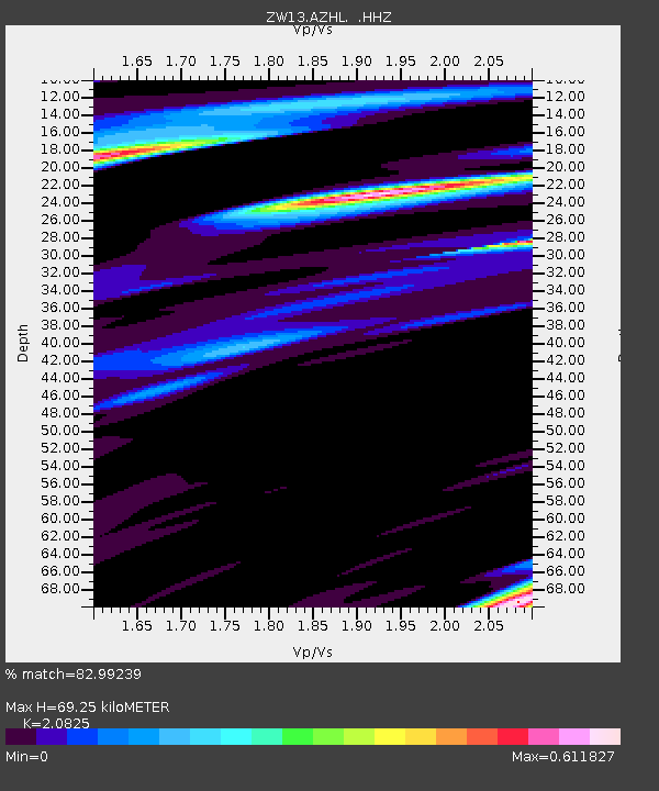
| Estimated Moho Depth: |
69.25 km |
| Estimated Crust Vp/Vs: |
2.08 |
| Assumed Crust Vp: |
6.38 km/s |
| Estimated Crust Vs: |
3.064 km/s |
| Estimated Crust Poisson's Ratio: |
0.35 |
|
| Radial Match: |
82.99239 % |
| Radial Bump: |
400 |
| Transverse Match: |
59.7791 % |
| Transverse Bump: |
400 |
| SOD ConfigId: |
626651 |
| Insert Time: |
2014-05-30 12:11:13.557 +0000 |
| GWidth: |
2.5 |
| Max Bumps: |
400 |
| Tol: |
0.001 |
|

Signal To Noise
| Channel | StoN | STA | LTA |
| ZW:AZHL: :HHZ:20140516T11:08:18.169991Z | 11.198011 | 1.3256489E-6 | 1.1838253E-7 |
| ZW:AZHL: :HHN:20140516T11:08:18.169991Z | 1.2697048 | 3.0866062E-7 | 2.4309637E-7 |
| ZW:AZHL: :HHE:20140516T11:08:18.169991Z | 2.6504915 | 5.729397E-7 | 2.1616357E-7 |
| Arrivals |
| Ps | 12 SECOND |
| PpPs | 31 SECOND |
| PsPs/PpSs | 44 SECOND |


