You are here: Home > Network List > CI - Caltech Regional Seismic Network Stations List
> Station VCS Vincent Substation, Palmdale, CA, USA > Earthquake Result Viewer
VCS Vincent Substation, Palmdale, CA, USA - Earthquake Result Viewer

| Earthquake location: |
Costa Rica |
| Earthquake latitude/longitude: |
8.8/-84.0 |
| Earthquake time(UTC): |
2002/06/16 (167) 02:46:14 GMT |
| Earthquake Depth: |
35 km |
| Earthquake Magnitude: |
5.4 MB, 6.2 MS, 6.4 MW, 6.4 MW |
| Earthquake Catalog/Contributor: |
WHDF/NEIC |
|
| Network: |
CI Caltech Regional Seismic Network |
| Station: |
VCS Vincent Substation, Palmdale, CA, USA |
| Lat/Lon: |
34.48 N/118.12 W |
| Elevation: |
991 m |
|
| Distance: |
40.4 deg |
| Az: |
314.368 deg |
| Baz: |
121.199 deg |
| Ray Param: |
0.07434802 |
| Estimated Moho Depth: |
25.75 km |
| Estimated Crust Vp/Vs: |
1.85 |
| Assumed Crust Vp: |
6.1 km/s |
| Estimated Crust Vs: |
3.306 km/s |
| Estimated Crust Poisson's Ratio: |
0.29 |
|
| Radial Match: |
96.47113 % |
| Radial Bump: |
400 |
| Transverse Match: |
91.95376 % |
| Transverse Bump: |
400 |
| SOD ConfigId: |
3787 |
| Insert Time: |
2010-02-25 21:05:13.621 +0000 |
| GWidth: |
2.5 |
| Max Bumps: |
400 |
| Tol: |
0.001 |
|
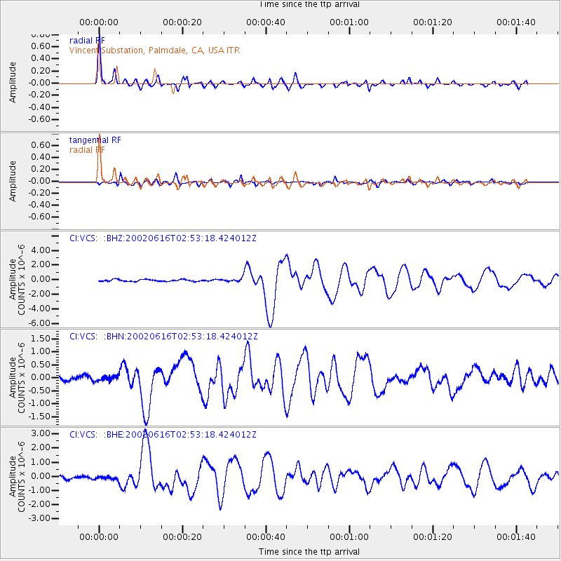
Signal To Noise
| Channel | StoN | STA | LTA |
| CI:VCS: :BHN:20020616T02:53:18.424012Z | 1.4388645 | 1.0183506E-7 | 7.0774604E-8 |
| CI:VCS: :BHE:20020616T02:53:18.424012Z | 0.955967 | 1.2554246E-7 | 1.313251E-7 |
| CI:VCS: :BHZ:20020616T02:53:18.424012Z | 2.3671293 | 2.9696383E-7 | 1.2545314E-7 |
| Arrivals |
| Ps | 3.8 SECOND |
| PpPs | 11 SECOND |
| PsPs/PpSs | 15 SECOND |


