You are here: Home > Network List > TA - USArray Transportable Network (new EarthScope stations) Stations List
> Station D04E Lakebay, WA, USA > Earthquake Result Viewer
D04E Lakebay, WA, USA - Earthquake Result Viewer
| Earthquake location: |
Solomon Islands |
| Earthquake latitude/longitude: |
-6.2/154.4 |
| Earthquake time(UTC): |
2014/04/21 (111) 09:04:24 GMT |
| Earthquake Depth: |
48 km |
| Earthquake Magnitude: |
5.6 MWW, 5.5 MWB, 5.6 MWC |
| Earthquake Catalog/Contributor: |
NEIC PDE/NEIC COMCAT |
|
| Network: |
TA USArray Transportable Network (new EarthScope stations) |
| Station: |
D04E Lakebay, WA, USA |
| Lat/Lon: |
47.18 N/122.77 W |
| Elevation: |
45 m |
|
| Distance: |
89.7 deg |
| Az: |
42.596 deg |
| Baz: |
260.536 deg |
| Ray Param: |
0.041721743 |
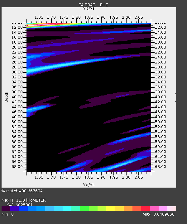
| Estimated Moho Depth: |
11.0 km |
| Estimated Crust Vp/Vs: |
1.60 |
| Assumed Crust Vp: |
6.566 km/s |
| Estimated Crust Vs: |
4.097 km/s |
| Estimated Crust Poisson's Ratio: |
0.18 |
|
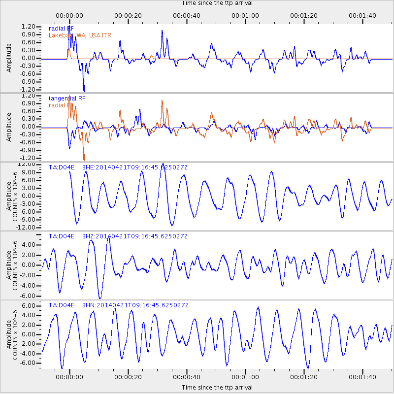
| Radial Match: |
80.667694 % |
| Radial Bump: |
400 |
| Transverse Match: |
62.944603 % |
| Transverse Bump: |
323 |
| SOD ConfigId: |
626651 |
| Insert Time: |
2014-05-30 12:25:29.197 +0000 |
| GWidth: |
2.5 |
| Max Bumps: |
400 |
| Tol: |
0.001 |
|
Signal To Noise
| Channel | StoN | STA | LTA |
| TA:D04E: :BHZ:20140421T09:16:45.625027Z | 1.6575768 | 2.6731625E-6 | 1.6126929E-6 |
| TA:D04E: :BHN:20140421T09:16:45.625027Z | 0.8730042 | 3.0658982E-6 | 3.511894E-6 |
| TA:D04E: :BHE:20140421T09:16:45.625027Z | 1.5750873 | 8.028868E-6 | 5.0974113E-6 |
| Arrivals |
| Ps | 1.0 SECOND |
| PpPs | 4.3 SECOND |
| PsPs/PpSs | 5.3 SECOND |


